Subject: Western United States
Period: 1853-54 (dated)
Publication: U.S. Pacific Railroad Surveys
Color: Black & White
Size:
50.7 x 22.1 inches
128.8 x 56.1 cm
During the 1850s, the U.S. government sponsored an extensive series of expeditions designed to gather information on the vast new territories that had been acquired in western North America. The discovery of gold in California further stimulated westward traffic and heightened the need for a faster and more convenient way to bring the far-flung parts of the country together. In 1853 Congress commissioned the Army's Topographic Bureau to conduct a series of surveys to find a suitable route for a transcontinental railroad. There were six major expeditions; five of them covered the area between the Great Plains and west coast, and the sixth explored the coastal states of California and Oregon. All of these expeditions were accompanied by naturalists and artists to document the landscape, flora and fauna along the route.
The reports, maps and lithographs were published in the 13 volume report "Explorations and Surveys to ascertain the most practicable and economical route for a Railroad from the Mississippi river to the Pacific Ocean."
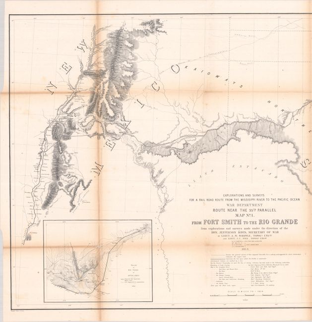
This impressive, immense pair of maps were published as part of the U.S. Pacific Railroad Surveys. The first map covers the region from Fort Smith, Arkansas west to Isleta, a tiny Indian pueblo on the Rio Grande. It has excellent detail along the route that follows the Canadian River then up Pajarito Creek and over the mountains near Albuquerque. Forts, mounds, trading posts, the Santa Fe Trail, Raton Pass, Taos, and Santa Fe are all located. Wheat calls this map noteworthy for it use of the contour system. The inset map "Sketch of Rio Pecos at Anton Chico" is the first map of this type to use the contour system. The map features a long list of authorities used for topography not covered by this survey. Wheat considers this list important as it gives all the surveys that had gone before it in the period 1846-1853.
The second map depicts the railroad surveys between Albuquerque and Los Angeles, with the Gila River on the bottom. The map details the route from Isleta (on the Rio Grande) past Laguna through Campbell's Pass and down the Rio Puerco of the West across New Mexico Territory to Los Angeles. Topography and hydrography are shown in great detail. Zuni and Inscription Rock are shown on the trail of Lt. Beckwith in 1847. Features insets "Sketches Aztec Pass" and "Sketch of Campbell's Pass" from Agua Azul to Salt Spring. This map is from the report on the route near the 35th parallel surveyed by Whipple and Ives. Both maps are printed on two joined sheets, as issued.
References: Wheat (TMW) #874 & #875.
Condition: B+
Both maps are issued folding, now flat, with light toning along the joints and folds, a few short separations at the fold intersections, and light foxing.