Subject: Southern United States, Franklin
Period: 1800 (published)
Publication: A Concise System of Modern Geography
Color: Black & White
Size:
14.1 x 11.8 inches
35.8 x 30 cm
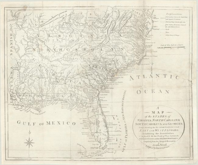
This is the final edition and state of the fine Purcell map naming the proposed state of Franklin. It is a fascinating historical document of the United States following the Revolutionary War. The map includes a reference to the New State of Franklin in western North Carolina. There is a great amount of information present on the map, including boundaries claimed by the various Indian Nations and trading paths on the western frontier. It shows early settlements, including a Moravian Settlement in North Carolina, and the Cumberland Settlements in present-day Tennessee. At the top of the map, in the nascent Northwest Territory, the 7 Ranges denote the first application of the Public Land Survey System. Several bounty land grants are shown including the Ohio Company, Wabash Company, New Jersey Company, Illinois Company, and the Donation Lands of the Commonwealth of Virginia. A triangular shaped plot of land in the region of present-day West Virginia is labeled Indiana.
In 1785, settlers in present-day western North Carolina and eastern Tennessee organized a state government to be named in honor of Benjamin Franklin, Franklin or Frankland. Congress turned down their appeal but the state maintained a legislature and governor until 1788. This ephemeral state appeared on a small number of maps into the early part of the 19th century.
The Revolutionary government of the United States used bounty land grants in their struggle for independence from Great Britain. The free lands exchanged for military service provided an effective technique for enrolling support for the war and encouraging re-enlistments. Generally the bounty lands were located on the western frontier, which provided another benefit to the government. Populating the frontier with citizens skilled in defense offered the best prospect in enticing other settlers to join them, thus eventually increasing the tax rolls.
The region shown on this map as Indiana was originally granted to a Philadelphia trading company by the Iroquois Confederacy in 1768. Then in 1776 it was sold to the Indiana Land Company, but was also claimed by the State of Virginia as a part of her original charter. The resulting battle between the private land company and Virginia resulted in the Eleventh Amendment to the U.S. Constitution and is one of the most interesting chapters in the history of the young United States.
Published in A Concise System of Modern Geography by Vint & Anderson, whose imprint appears below the title cartouche.
References: Dotson & Baker (OWA) #11.2; Baynton-Williams (TMC-72) p. 16, #6; McCorkle (18th C. Geography Books) #438 Vol. II-6.
Condition: B
Issued folding, now flat, on a sheet with a fleur-de-lis watermark and a binding trim in the bottom right margin that has been replaced with old paper. There is light soiling and a 9" tear at right with a few associated areas of minor image loss that have all been closed with archival materials on verso.