Subject: Continents
Period: 1628 (circa)
Publication: Gerardi Mercatoris - Atlas sive Cosmographicae
Color: Hand Color
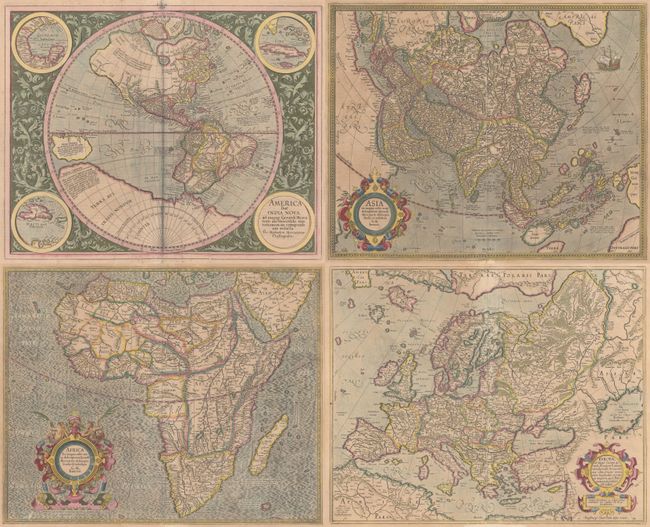
This is a handsome matching set of continents from a French edition of Mercator's Atlas, published in both 1628 and 1633. This set includes:
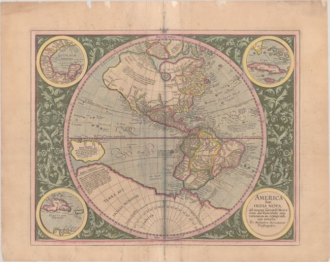
A. America sive India Nova, ad Magnae Gerardi aui Universalis Imitationem in Compendium Redacta, by Michael Mercator (18.1 x 14.6"). This is one of the most famous maps of the Americas and an important foundation map for an American map collection. After the death of his grandfather, Michael Mercator produced this stunning hemispherical map, the only known printed map attributed to him. The map is surrounded by a beautifully engraved floral design and four roundels, one of which contains the title. The other insets include the Gulf of Mexico, Cuba, and Haiti. The geography was patterned after Rumold Mercator's world map of 1587, with a little added detail. There is a large inland lake in Canada, and the St. Lawrence River extends nearly halfway across the continent with no Great Lakes. There is a still a bulge in the west coast of South America. The large southern continent extends above the Tropic of Capricorn in the Pacific where there is a very large island of New Guinea. Above North America are two of the four islands of the North Pole, with the great mythical rivers flowing from the pole. The seas are full of mythical islands, including St. Brendain, Frislant and Sept citez. References: Burden #87; Van der Krogt (Vol. I) #9000:1A. Condition: A nice impression on a lightly toned sheet with archival repairs to a long tear to the left of the centerfold and to two shorter tears to the right of the lower centerfold measuring 2.5" and 3.5" respectively. Additional repairs have been made to small centerfold separations as well as edge chips and tears in the margins. There is some light staining along the centerfold and creases flanking the centerfold. (B)
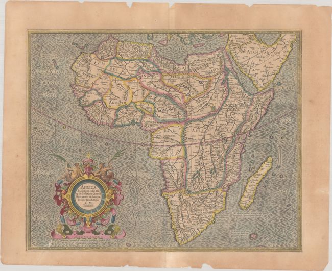
B. Africa ex Magna Orbis Terre Descriptione Gerardi Mercatoris Desumpta, Studio & Industria, by Gerard Mercator (the younger) (18.5 x 14.9"). Compiled from Gerard Mercator's world map of 1569, this rendition was drawn by Mercator's grandson (also named Gerard) in 1595, and published later by Hondius. The map is typical of 16th century cartography with considerable fantastic detail in the interior. The depiction of the Nile is based on Ptolemy's geography with some complex modifications from various sources, including Abyssinian monks. The source of the Nile is shown as a series of lakes located in the Lune montes just north of the Tropic of Capricorn. Another branch of the Nile flows from the west, with this system rambling through what is the Sahara Desert. Mercator adds a lake named Sac. Haf lac, from the 1507 Waldseemuller world map. This lake feeds both the Zambere River and the Nile. In Abissini, the legendary Christian King Prester John sits on his throne. The boldly engraved oceans, beautiful calligraphy, and strapwork cartouche (surmounted by two satyrs) make this a decorative masterpiece. References: Betz #31; Norwich #21; Van der Krogt (Vol. I) #8600:1A. Condition: On a lightly toned sheet with archival repairs to centerfold separations at top and bottom and one small tear at lower left. There are some small chips and edge tears in the top and bottom blank margins. (B+)
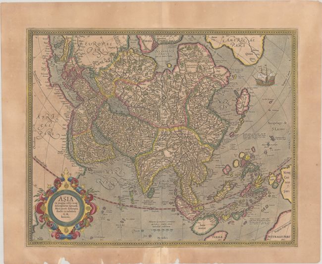
C. Asia ex Magna Orbis Terre Descriptione Gerardi Mercatoris Desumpta, Studio et Industria, by Gerard Mercator (the younger) (18.4 x 14.8"). This map also derived from the elder Mercator’s world map of 1569. The coasts of Northeast Asia and Northwest North America are separated by Gastaldi's fabled Strait of Anian. South of this strait a beautifully engraved galleon gives speculation to the possibility of a northern route to Asia. Sumatra has a curiously archaic outline, while the relationship between New Guinea and Terra Australis is left to the viewer's imagination. The place names, Beach, Regio, Lucach and Maletur are all taken from Marco Polo's account, but erroneously ascribed to locations in the vicinity of present-day Australia. References: Yeo #13; Parry #3.13, Van der Krogt (Vol. I) #8000:1A. Condition: On a moderately toned sheet with a long centerfold separation that has been archivally repaired on verso. There are a number of small repaired edge tears and chips mostly in the bottom margin. (B)
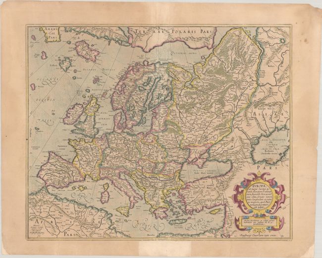
D. Europa, ad Magnae Europae Gerardi Mercatoris P. Imitationem, Rumoldi Mercatoris F. Cura Edita, Seruato Tamen Initio Longitudinis ex Ratione Magnetis, quod Pater in Magna sua Universali Posuit, by Gerard Mercator (18.6 x 15.1"). A beautiful map in Mercator's strong engraving style with the seas filled with waves and the land dotted with tiny cities. All of Europe is depicted, as well as Americae Pars, Greenland, Iceland, a Polar landmass, along with the mythical islands of Frisland, Drogeo, and Bradain. A large strapwork title cartouche completes the sheet. References: Van der Krogt (Vol. I) #1000:1A. Condition: On a lightly toned sheet with a tiny rust hole at right and a long centerfold separation that has been archivally repaired on verso. There are several small repaired edge tears in the bottom margin and chips in the bottom corners that have been replaced with old paper. Additional reinforcement has been made with old paper in the bottom margin on recto. (B+)
References: See description.
Condition:
See description.