Subject: Southeastern Australia
Period: 1850 (circa)
Publication: Illustrated Atlas and Modern History of the World
Color: Hand Color
The maps from The Illustrated Atlas were first published in serial form to a target audience that led insular lives due to the expense and hardship of travel. All that changed as the progress of the nineteenth century brought swift and dramatic changes in public awareness of far away places. Tallis' maps no doubt played an important role in this dramatic awakening. These maps not only provided up-to-date geographical knowledge, but also used vignette views within the map's design to show the native people and their occupations, cities and points of interest. The maps hark back to a cartographic tradition from the Dutch mapmakers of the seventeenth century with finely engraved decorative borders. The maps were drawn and engraved by John Rapkin with views drawn and engraved by a number of prominent artists. The maps were issued as a complete volume from 1851 until about 1865. Some of the maps were also published in other history books published by Tallis including British Colonies and, without the vignettes, in geographical dictionaries and encyclopedias until about 1880.
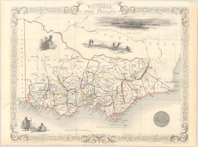
A nice pair of steel-engraved maps with decorative borders representing Tallis' view of southern Australia:
A. New South Wales, (9.8 x 13.4"). Lovely map of New South Wales with remarkable detail along the coastline. The map predates the discovery of gold in New South Wales and does not contain the notations concerning gold diggings found in later issues. There are well-rendered vignettes of the seal of New South Wales, Sydney, the Murray, and a plant called Xanthorrhaea. This uncommon edition features a vignette of a bird's-eye view of the city of Sydney rather than its harbor. The vignettes were drawn by H. Warren and engraved by J. Rogers, while the map was drawn and engraved by J. Rapkin.
B. Victoria, or Port Phillip, (12.8 x 10.3"). Superb map of Victoria roughly centered on Melbourne. The map is peppered with vignettes of Aborigines, a kangaroo, and a large view of Melbourne across the water with a sailing ship and two early steam ships maneuvering in the foreground. This edition features a seal at bottom right instead of the idyllic scene on the Glenelg River seen in other editions. The illustrations were drawn by A. Warren and engraved by J. Rogers; the map was drawn & engraved by J. Rapkin.
References:
Condition: A
Contemporary outline color on bright sheets with a couple minor spots and marginal toning. The Victoria map has binding holes along its upper margin.