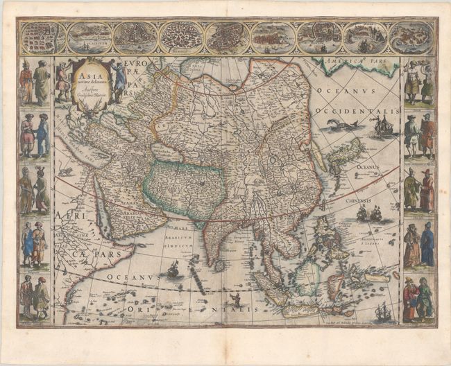
Subject: Asia
Period: 1630 (circa)
Publication: Atlantis Appendix
Color: Hand Color
Size:
21.8 x 16.1 inches
55.4 x 40.9 cm
This is one of the most famous 17th century maps of the continent of Asia. It is surrounded by a beautiful carte-a-figures border and is richly ornamented with animals, sea monsters, and sailing ships. The eastern coastline of Asia is severely truncated, Korea is shown as an island, and Japan is depicted on the Ortelius-Teixeira model. The Indian subcontinent is too narrow and the islands of Indonesia are very sketchy. A large island labeled Ceiram probably represents the western part of New Guinea. In the interior, the Caspian Sea is oriented on an east-west axis and there are several large erroneous lakes in China including the mythical Chiamay Lacus. The frieze across the top features vignettes of the cities of Candy, Calecut, Goa, Damascus, Jerusalem, Hormuz, Banten, Aden, and Macao. The inclusion of Banten reflects the emergence of the Dutch as a major commercial power in the East Indies. The side panels flanking the map depict costumed figures of the various Asian peoples. This is an early edition prior to the evidence of a crack in the copperplate at bottom center. Blank verso, published between 1634-35.
References: Van der Krogt (Vol. II) #8000:2; Walter #25; Yeo #24.
Condition: B
A dark impression with printer's ink residue, light soiling, a few old manuscript ink notations in the image, and professional repairs to several short tears in the image. The map was trimmed on all sides just within the image, with the image expertly replaced in facsimile and the margins replaced with old paper. Along the top and bottom edges of the map, the beaded border has been replaced in facsimile, and along the sides of the map approximately 1 cm of the image has been replaced.