Subject: Southern California, Los Angeles
Period: 1881 (dated)
Publication: U.S. Geographical Surveys West of the 100th Meridian
Color: Printed Color
Size:
20.3 x 15.1 inches
51.6 x 38.4 cm
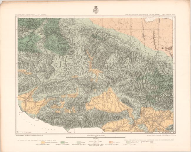
The 1870s was a period of intense effort, by such prominent people as Clarence King, Ferdinand Hayden, and John Wesley Powell, to advance the geographical knowledge of the West. These various surveys presented a threat to the Army's supremacy in the field of mapping and to the related appropriations from Congress. As a result of these pressures, the Army Corp of Engineers developed a plan to systematically survey the entire West to be called the U.S. Geographical Surveys West of the One Hundredth Meridian. The region was divided up into 95 rectangles, with atlas sheets to be prepared for each, comprising an area 2°45' of longitude and 1°40' of latitude on a scale of eight miles to the inch. Lieutenant George Wheeler was chosen to head this immense project. Surveys were conducted each summer from 1872 to 1878, after which Congress cut off appropriations for field work; thus the survey was not completed as originally envisioned. Wheeler published annual reports from 1873 to 1884, as well as the final Geographical Report published in 1889. The maps from this report are a valuable document of the record of Western exploration.
This map is from Wheeler's series of maps showing land classification by type including Agriculture, Timber, and Grazing, as well as Arid/Barren and Chaparral. It is based upon surveys taken in 1875 and 1878, and covers the region from the present-day Angeles National Forest south to the San Fernando Valley and east to the Mojave Desert. It features fine detail of the mountain ranges, river systems, and early settlements including early depictions of Los Angeles, Machado, Santa Monica, Encino, Lancaster and more. Along the coast a "Wagon Trail" extends from Santa Monica to Port Hueneme, following the path of today's Pacific Coast Highway. Finely colored in green, yellow and ochre with varying line, revealing that well over 50% of the region was either agricultural or grazing lands. On a detailed scale of 4 miles per inch.
References: Phillips (Atlases) #1281-138.
Condition: A
On a clean sturdy sheet with minor toning along the top edge, well away from the map image.