Subject: Northwestern United States & Canada
Period: 1872 (circa)
Publication:
Color: Black & White
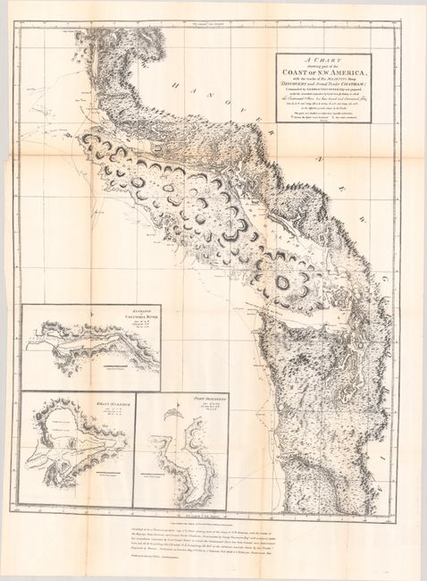
A. A Chart Shewing Part of the Coast of N.W. America, with the Tracks of His Majesty's Sloop Discovery and Armed Tender Chatham..., by (Capt.) George Vancouver, circa 1872 (21.6 x 27.7"). This is the 1872 reproduction of Vancouver’s 1798 map that was part of the British presentation in the Berlin Arbitration, concluded in 1872, that settled the boundary dispute between the United States and Britain over San Juan Island that had precipitated the Pig War of 1859. This is an example of the process of photozincography the British Ordnance office had developed and noted at bottom as "certified to be a photozinco-graphic copy."
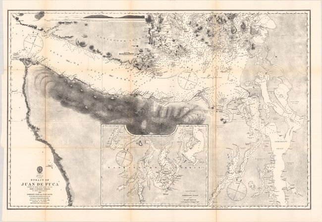
B. America N.W. Coast - Strait of Juan de Fuca Surveyed by Captain Henry Kellett, R.N. 1847. Haro & Rosario Straits … Admiralty Inlet and Puget Sound, by U.S. Hydrographic Office, (33.8 x 22.3"). This uncommon lithographed chart details the Strait of Juan de Fuca, Admiralty Inlet, Puget Sound and the waters in the vicinity of the San Juan Islands. It includes an inset chart "Continuation of Admiralty Inlet and Puget Sound." Details on the map include thousands of soundings given in fathoms, hachuring of the mountains surrounding the strait, with numerous tribal lands located and named. A few settlements are noted: Victoria, Olympia, Fort Nisqually, Fort Steilcoom, and Seattle. This is a very early mention of Seattle, which was not incorporated until 1865. The incorporation was disbanded in 1867 due to unrest and was not permanently renewed for another two years. Much of the map's cartography is credited to the U.S. Exploring Expeditions of 1841 and 1853. The map is dated 1858, but a note that states "Magnetic Variation in 1866" indicates this is a revised edition.
References:
Condition: B+
Both maps are issued folding with light toning along the folds and some fold separations, most of which have been closed on verso with archival tape.