Subject: Colonial North America
Period: 1758 (circa)
Publication:
Color: Hand Color
Size:
9.1 x 7.3 inches
23.1 x 18.5 cm
Thomas Jefferys was one of the most important English map publishers of the 18th century. His work included prints and maps of locations around the world, but his most notable maps are of North America and the West Indies. He began his career in the map trade in the early 1730s, working as an engraver for a variety of London publishers, and eventually setting up his own shop. In 1746, he was appointed Geographer to the Prince of Wales, and in 1760 he became Geographer to the King. These titles granted access to manuscripts and cartographic information held by the government. In the early 1760s he embarked on an ambitious project to produce a series of English county maps based on new surveys, but ran out of money and filed for bankruptcy in 1766. He then partnered with London publisher Robert Sayer, who reissued many of Jefferys plates and continued to issue new editions after Jefferys' death in 1771. Jefferys' American Atlas and the accompanying West-India Atlas, published post posthumously, are considered his most important cartographic works.
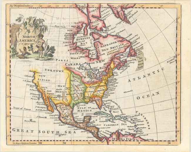
This small map of North America includes a curious representation of the Mississippi River, a triangular Florida with a spurious mountain range, and a nice depiction of all the Great Lakes. The West is largely blank, with vast areas labeled Parts Unknown and New Albion. Great Teguaio appears north of the Gulf of California. Detail on the California coast extends to C. Blanco, with the entire northwestern part of the continent left open-ended. In the Atlantic, the Great Fishing Bank is located. The early British colonies are named. Native Americans grace the scenic title cartouche. The map appeared in several editions of Thomas Salmon's The Modern Gazetteer and A New Geographical and Historical Grammar.
References: McCorkle (18th C. Geography Books) #334-6.
Condition: B+
A crisp impression, issued folding and now flat, with minor offsetting from an opposing page of text and a couple faint spots.