Subject: Northern Asia
Period: 1679 (circa)
Publication: Die Gantze Erd-Kugel...
Color: Hand Color
Size:
9.9 x 7.5 inches
25.1 x 19.1 cm
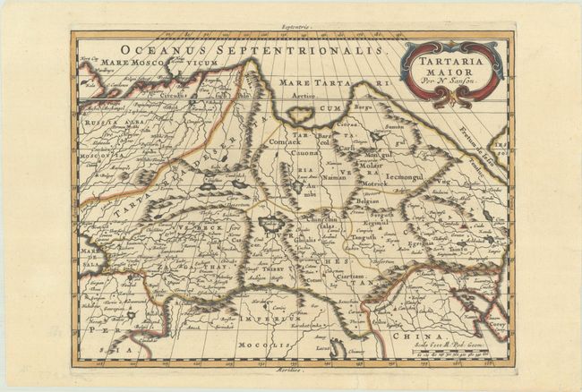
Attractive map of Siberia, northern China, and Korea, which is shown here as an island. The cities, mountains, and rivers are well-detailed. The mythical Lacus Chiamay peeks in at the bottom of the map, and a fragment of Iesso appears at right. Siberia still reflects some of Ptolemy’s conceptions, with the Island of Tazata and the Cape of Tabin in the extreme north (shown but not named). The map is decorated with a lovely title cartouche as well as a beautiful compass rose. An uncommon edition with a Latin title, published by Johann David Zunners.
Sanson's small maps from his L'Amerique en Plusieurs Cartes..., first published in 1657 and engraved by A. Peyrounin, were copied several times by various map publishers. Johann David Zunners made copies of Sanson's maps for his German translation of Die Gantze Erd-Kugel in 1679. Johannes Ribbius and Simon de Vries published copies in 1682 and 1683, with new maps engraved by Antoine d'Winter. The plates were later sold to Francois Halma, who used them in 1699 and then again in 1705 with the titles re-engraved in Dutch. The titles on the d'Winter plates were re-engraved back into French, and then used by Nicholas Chemereau in 1715 and by Henri du Sauzet in 1738.
References: Pastoureau, SANSON III E.
Condition: A
A sharp impression with a few short edge tears in the bottom blank margin that have been archivally repaired.