Subject: Western Hemisphere - America
Period: 1730 (circa)
Publication:
Color: Hand Color
Size:
22.6 x 19.3 inches
57.4 x 49 cm
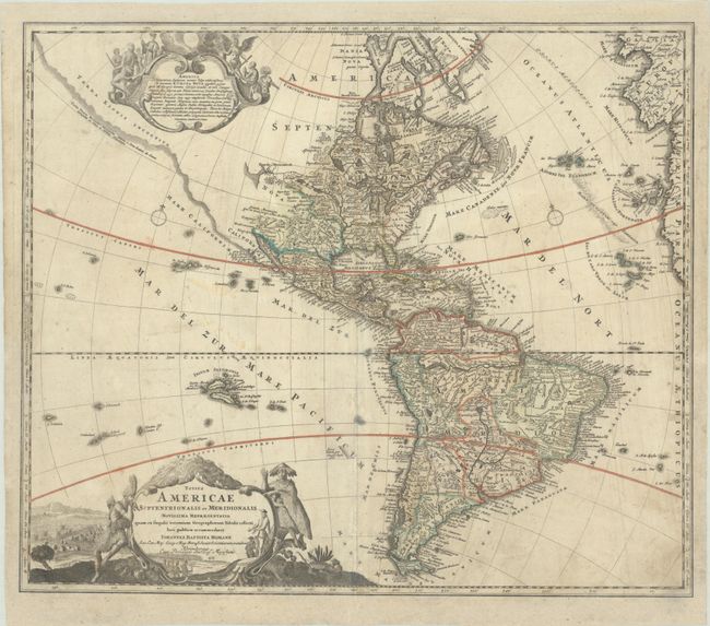
This attractive map is a revision of the elder Homann's 1710 map of the Americas. After his death in 1724, his son (Johann Christoph Homann) re-engraved the plate to correct the western coastline of North America, shown here extending very far west and north, with very little detail. The coastline is labeled Costa Terrae Borealis and is attributed to the reports by João da Gama, who sighted land while traversing the Pacific Ocean in 1589-90. California is no longer shown as an island, although the remnants of the interior sea can be seen near the Pais de Moozemleck, where a river nearly connects with the Mississippi River system, hinting at the possibility of a Northwest Passage. The Great Lakes are taking shape, being actively explored by the French fur traders and the Hudson Bay Company. The Solomon Islands are prominently placed in the Pacific, considerably too far to the east. The map is decorated with two large pictorial cartouches; the one at top shows natives worshiping a fearsome demon at the right, while at left they listen placidly to a priest. The lower cartouche also features the landscape and native fauna.
References:
Condition: B
On a watermarked sheet with professional reinforcement along the top and bottom edge and centerfold. There are some separations along the centerfold that have been archivally repaired, soiling and small stains, and a tiny area of loss in the lower border that has been replaced in facsimile.