Subject: Ireland
Period: 1712 (dated)
Publication: The English Atlas...
Color: Hand Color
Size:
26.4 x 38.1 inches
67.1 x 96.8 cm
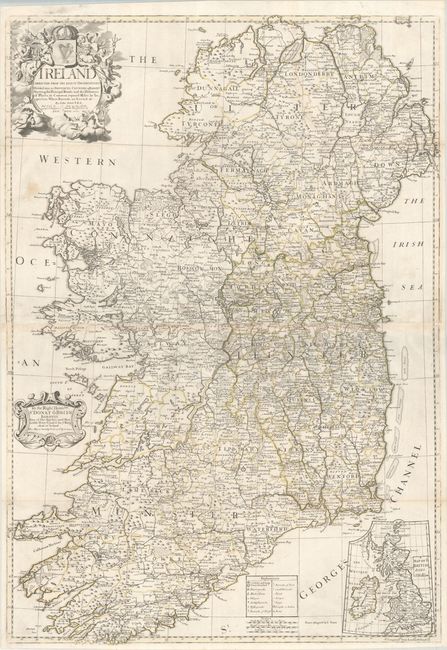
This handsome large map is joined on two sheets and depicts Ireland in its entirety. It is delineated by several political divisions, with a legend at bottom identifying fortified cities and towns, market towns, barracks, roads, ferries, forts, and even boggs. The map also includes "distances of places, in common reputed miles, by inspection, where barracks are erected." An inset at bottom right depicts the full British Isles. Elaborately embellished by a title cartouche featuring allegorical representations of harvest and music surrounding the Irish coat of arms. A secondary cartouche at lower left contains a dedication to Sir Donough O'Brien (1642-1717), 1st Baronet of Leameneh.
References: Shirley (BL Atlases) T.SEN-1c #8.
Condition: B+
Issued folding and now flat on a bright sheet with contemporary outline color. There are professional repairs to two long tears at right (9" and 10") as well as four fold separations (ranging from 3" to 8"). There are a few other minor repairs and light toning along the joint.