Subject: Eastern United States
Period: 1839 (published)
Publication:
Color: Hand Color
Size:
5.5 x 9 inches
14 x 22.9 cm
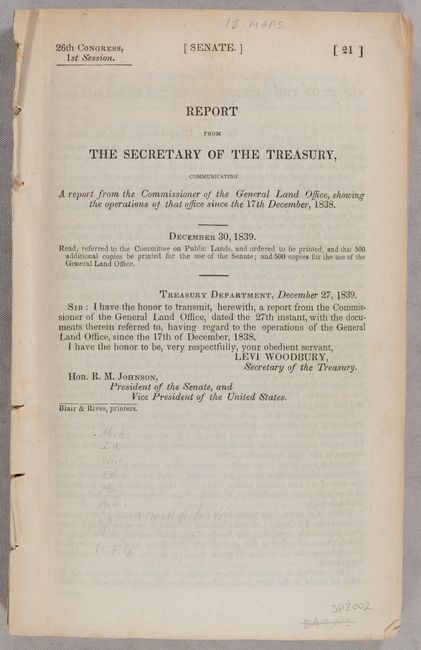
This 112-page report contains twelve early maps by the General Land Office. Each map is drawn on the scale of 18 miles per inch and all are hand colored.
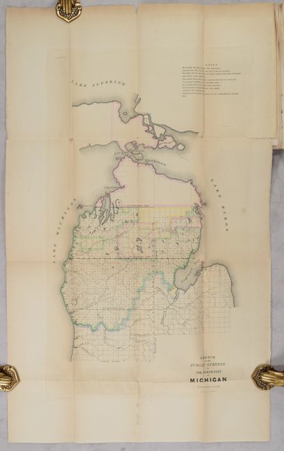
A. Sketch of the Public Surveys in the North Part of Michigan, (11.9 x 20.3"). By W.J. Stone this map locates Grand Traverse Bay, Saginaw Bay, Mackinaw Island and shows good watershed detail north from the Kalamazoo River. There is a repaired binding side tear and some toning. (B+)
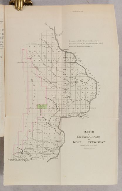
B. Sketch of the Public Surveys in Iowa Territory, (7.0 x 9.8"). By W.J. Stone this map is centered on Iowa City and locates Salem, Bloomfield, Eldford, Davenport, etc. Good watershed detail and the townships are colored to indicate the progress of surveys. (A)
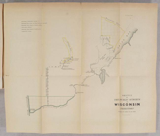
C. Sketch of the Public Surveys in Wisconsin Territory, (12.3 x 10.0"). Extends from Prairie du Chien to Green Bay and also to show part of the valley of the Wisconsin River where Grigon's Trading & Farming Establishment, several mills including Conant's, and Whitneys, and Yellow Banks and Plover Portage are identified. Locates the lands of the Stockbridge and Oneida Indians. Hand colored to indicate the progress of surveys. Light toning. (B+)
D. Diagram of the State of Illinois, (12.5 x 21.3"). Shows the entire state with townships hand colored to indicate the progress of surveys. Major towns are located. A short edge split at top and a little toning on lower fold. (B+)
E. Diagram of the State of Missouri, (22.0 x 17.5"). Shows the entire state with townships hand colored to indicate the progress of surveys, which is in very early stage. Major towns are located. (A+)
F. Arkansas, (17.0 x 15.5"). Very nicely color using a wider pallet than normally seen in early GLO maps. Great detail of watershed and towns and settlements in the state. The region in the southwest is Disputed Territory. (A)
G, H, I, & J. [Four Maps of Louisiana] St. Helena District La., (7.3 x 4.8"). (A) Map of the District North of Red River La., (9.8 x 8.0"). (A) South Eastern District Louisiana, (9.3 x 8.0"). (A) Map of the South Western District Louisiana, (10.3 x 13.0"). Light toning and minor offsetting. (B+) Each township is noted and the hand colored one indicate the progress of surveys.
K. Diagram of the Surveying District South of Tennessee, (11.0 x 16.0"). Centered on Jackson the map names Grand Gulf, Natches, Vicksburg, Granada, and Columbus. Good detail of the Pascagoula, Pearl, Big Black and Yallobusha rivers. Locates the Choctaw Cession of 1830 and the Old Choctaw Boundary. Hand colored in several colors to indicate the progress of surveys. Light toning and a couple of fold separations. (B+)
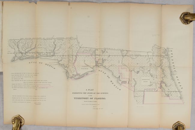
L. A Plat Exhibiting the State of the Surveys in the Territory of Florida, (23.0" x 9.8"). This early, interesting map shows the status of public land surveys in the Eastern and Western Land Districts of the Florida Panhandle. Red outlines the boundary of the Forbes Purchase. St. Augustine, Amelia Island, and Tallahassee are named. An area outlined in red is designated "Supposed Indian Boundary Line" while the legend indicates that red outlining is used to indicate proposed new survey areas. Survey efforts in south Florida continue to be hampered by the guerilla warfare of the Second Seminole War (1837-1842). From the Surveyors Office in Tallahassee by Robert Butler Survey General Territory of Florida. A little fold toning and minor offsetting. (B+)
References:
Condition:
Report very good with only occasional toning and foxing. Maps with contemporary color; see individual descriptions for additional condition detail.