Subject: United States
Period: 1857 (dated)
Publication: Mitchell's New Universal Atlas
Color: Hand Color
Size:
26.4 x 15.9 inches
67.1 x 40.4 cm
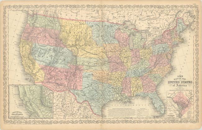
This is the uncommon edition published by Charles Desilver, 251 Market Street, Philadelphia. It features an inset of the Gold Region of California and contains some of the largest western territorial boundaries. The extensive Kansas Territory borders Utah and New Mexico as there is no Colorado. Washington and Oregon both spread eastward to the Rocky Mountains at the Continental Divide. Utah and New Mexico are both shown at their largest configuration, with New Mexico occupying the entire Southwest. A large area in the southern portion of today's Nevada is Unexplored Region. Minnesota Territory stretches to the Missouri River, which it shares as a boundary with a huge Nebraska Territory that extends north to the Canadian border and west to the Continental Divide in the Rocky Mountains. The map is filled with details and place names, forts, Indian tribes, emigrant roads, and much more. Several exploration routes are shown, including those of Fremont, Marcy, and Kearney. The proposed routes for the "Great Pacific Railroad" are traced. A second inset contains a plan of the District of Columbia. The map is copyright 1856, but this edition is dated 1857 in the title.
References:
Condition: B+
Contemporary color with light foxing. There is light toning along the sheet's edges and a few short edge tears confined to the blank margins.