Subject: Western England
Period: 1610 (dated)
Publication: The Theatre of the Empire of Great Britaine
Color: Hand Color
Size:
19.9 x 15.1 inches
50.5 x 38.4 cm
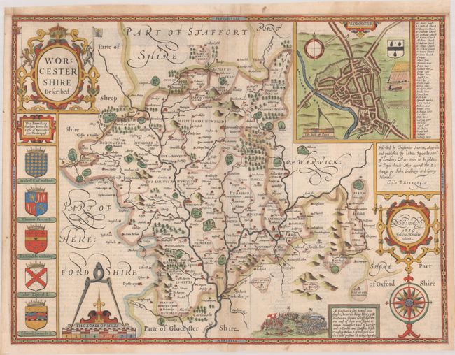
This handsome decorative map of Worcestershire is from John Speed’s groundbreaking English atlas. It divides the county into its hundreds and includes up-to-date detail on towns and cities, parks, forests, hills, rivers, and more. There is an inset town plan of Worcester at top right complete with a compass rose, distance scale, coat of arms featuring 3 Black Worcester pears, and a key identifying 41 sites of interest. The Battle of Evesham (August 1265) is depicted in a vignette at bottom accompanied by a note telling the story of the battle. Below the elaborate title cartouche at left, there are 5 coats of arms representing titled families since the conquest. The composition of this beautiful map is completed by a compass rose and cartouches for the scale of miles and publishers' and engraver's imprints. Engraved by Jodocus Hondius. Published by John Sudbury and George Humble. English text on verso.
References: Shirley (BL Atlases) T.SPE-1b.
Condition: B+
A sharp impression on a sheet with a bunch of grapes watermark, light toning along the centerfold and a bit of show-through of text on verso. A centerfold separation at bottom has been repaired with old paper on verso, and the sheet has been remargined at top.