Subject: Virginia & West Virginia
Period: 1859 (dated)
Publication:
Color: Hand Color
Size:
47.5 x 29.8 inches
120.7 x 75.7 cm
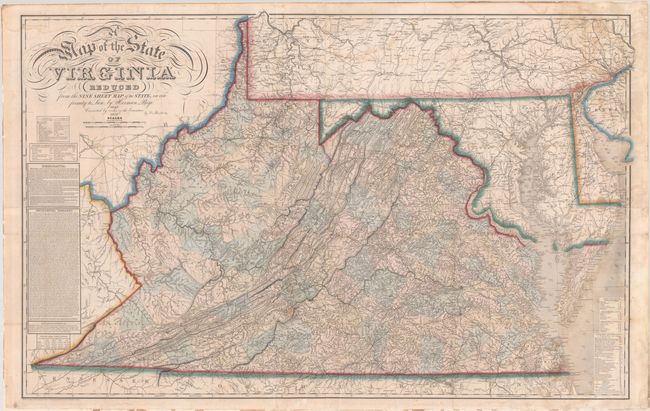
This is the rare 1859 update of Herman Boye's four-sheet map of the state published in 1827. It is widely considered to be one of the most important maps of Virginia. Historian Fairfax Harrison aptly summarized that "not only does it show the physical features of the country, mountains, streams and roads, but it shows them correctly for the first time on any map."
In 1816, the Virginia legislature appropriated $50,000 for the creation of an up-to-date map based upon actual county surveys. This enormous task was carried out primarily by John Wood, a teacher and cartographer, based upon the recommendation of Thomas Jefferson. Wood’s mandate was to create an accurate map of each county on a scale of 200 poles (3,300 feet) per inch as well as a general map of the entire state. While Wood finished most of the county survey work, he died before the completion of the general map, and Herman Boye was appointed in 1822 to finish the project. The map was finally published in 1827, having been engraved by Henry Tanner in Philadelphia. There were 400 copies made of the large 9-sheet version and 800 copies of the reduced 4-sheet version, from which this 1859 example is derived. Governor Giles noted that this new map was "considered, by connoisseurs, as unequaled." In the end, the map cost the Commonwealth of Virginia $80,000 to complete - a staggering amount of money for the time, and spoke to the value the legislature put in this map.
Boye's map was the cartographic standard for Virginia for the following 30 years. However, it became outdated as growth in the western part of the state created new counties and the state had initiated several new internal improvement projects requiring accurate maps. The state legislature did not have the appetite for another large cartographic expenditure, so instead approved funds for updating the original copper plates. Ludwig von Bucholtz, a German emigrant, was hired by Cladius Crozet, Chief Engineer of the Virginia Board of Public Works, in 1852 to complete the revision of both the original nine-sheet map as well as a reduced four-sheet version. Bucholtz compiled new geographical data including sketch maps for individual counties as well as incorporating corrections to the 1827 Boye map from county officials. Including the time for compilation, revisions, and printing, the new map was finally published in 1859. This new map added additional place names, enlarged cities and towns, and added new railroads and canals. A legend revealed further local knowledge including mills, minerals, "manufactories," iron works, colleges, churches, and "places remarkable for military incidents." The resulting map had the identical look and feel of the 1827 Boye map with more up-to-date information. As the Civil War began only two years after this map's publication, it was prized by both sides of the conflict. When Confederate General Garnett was killed in battle during the early stages of the war, Union Captain (and friend before the war) Henry Benham returned Garnett's body to his family, but the Bucholtz map he possessed was "Reserv[ed] for our own use, as much needed, a fine map of Virginia."
This map is rarely encountered on the market. While Stephenson & McKee note that there were 650 copies of this 4-sheet map produced, few of them appeared to have survived. In fact, we found no auction records and only two dealer listings for this map in the last 50 years. Thirteen institutional holdings were located on OCLC including the Library of Virginia, New York Public Library, Harvard, and Library of Congress.
References: Ristow, pp. 121-123; Stephenson & McKee #III-9, pp. 121-24; Wooldridge #215, pp. 216-19, 253-57.
Condition: B+
Expertly conserved with bright contemporary outline color. Issued folding and now flattened and backed with Japanese paper to reinforce and repair numerous mostly small fold separations as well as a few small areas of loss, most notably at a fold junction in Bath County. There is minor foxing and light dampstaining at right and top. A full conservation report is available upon request.