Subject: Western Hemisphere - America
Period: 1740 (circa)
Publication:
Color: Hand Color
Size:
22.6 x 19.6 inches
57.4 x 49.8 cm
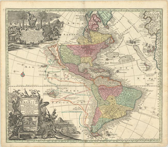
This striking map of the Americas features a prominent island of California based on the second Sanson model, with two indented bays in the northern coast. Directly above the island is the strait of Fretum Anian and the coastline of Terra Esonis incogn, which is obscured by an elaborate pictorial cartouche relating to the religious conversion of the natives. The Great Lakes are somewhat distorted, with large spurious bays on the west coasts of lakes Superior and Michigan. A suggestion of a Northwest Passage is hinted at through a portage between rivers inspired by the reports of Baron Lahontan. The map is filled with place names and details the tracks of the major voyages of exploration in the Pacific. An array of exotic birds flutter above the large title cartouche that depicts Native Americans fishing, cutting sugar cane, farming, and paying tribute to a chief. A secondary cartouche contains text relating the important discoveries in America and the conversion of the natives to Christianity. This is the second state with Clima labels in the side borders.
References: McLaughlin #211-2; Tooley (Amer) pp. 132, #91, plt. 61.
Condition: A
A sharp impression with full contemporary color on a bright sheet with an "SB" watermark. There are a few minute worm holes, a short centerfold separation at bottom, and marginal soiling. A 1/2" tear at bottom has been closed on verso with archival tape.