Subject: South Pacific Ocean & Australia
Period: 1790 (circa)
Publication: Voyages dans l'Hemisphere Australe...
Color: Hand Color
Size:
26.1 x 14.1 inches
66.3 x 35.8 cm
Captain James Cook (1728-1779) is best known for his three voyages to the Pacific (1768-71; 1772-75; and 1776-79). His discoveries radically changed the western understanding of the world in the late 18th century. He was the first to circumnavigate and chart New Zealand and provided the earliest European accounts of exploration along the eastern coast of Australia and the Hawaiian Islands. On February 14th, 1779, he was killed on Hawaii after attempting to kidnap the chief of the island.
Many contemporary accounts of Cook’s voyages, including charts and engravings, appeared in the late 18th century. The first official account of Cook’s first voyage was published in 1773 by John Hawkesworth in Volumes II and III of An Account of the Voyages Undertaken by the Order of His Present Majesty for Making Discoveries in the Southern Hemisphere... William Strahan and Thomas Cadell published the first official accounts of the second and third voyages in 1777 and 1784. Accounts of his exploration were subsequently translated into French, German, and Dutch.
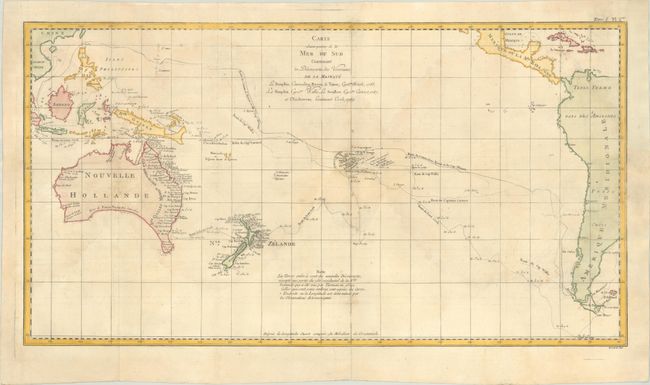
Captain James Cook is believed to be the greatest navigator of his day, and contributed to the mapping of Australia and the Pacific more than any other explorer. During his first voyage of 1768-71 on the Endeavour, he charted New Zealand and the eastern coast of Australia. This map follows the voyages of Cook and other explorers of the South Pacific Ocean between 1765 - 1769. The routes of Byron, Mouats, Wallis, Carteret, and Cook are depicted, with indications of the dates of their travels and their discoveries. A notation on the map indicates that the shaded coastlines are the new discoveries of these explorers. The southeastern tip of Australia is still connected to Tasmania, and the inland area is blank as it was still unexplored at the time.
References: Tooley (Australia) p. 46 #334.
Condition: B+
Issued folding on a sturdy sheet with a birdhouse watermark, light toning and offsetting, and large, faint dampstains in the image.