Subject: Western Africa
Period: 1732 (circa)
Publication: A Collection of Voyages and Travels...
Color: Black & White
Size:
13.4 x 9.8 inches
34 x 24.9 cm
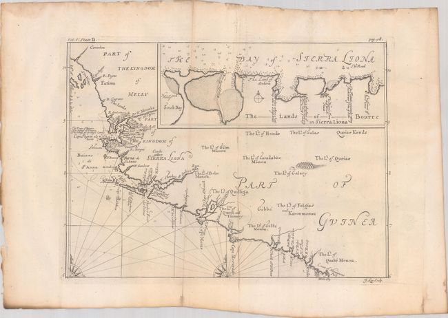
This elegantly engraved map centers on the coast of present-day Sierra Leone, extending into Guinea and Liberia. It first appeared in Volume V of Awnsham and John Churchill's A Collection of Voyages and Travels... in 1732. The map draws on the accounts of John Barbot, a French Huguenot slave trader, who made two journeys to Western Africa in 1678 and 1682. The map covers the stretch of coast from the Iles de Los south to the land of the Quabe Monou at the mouth of the Cestos River. Soundings, anchorages, and hazards are indicated along the coast, especially near the mouths of the Mitomba (Sierra Leone) and Sherbro rivers. There is little information inland aside from tribal names, as is typical of maps of Africa during this era. An inset of the Bay of Sierra Leone includes navigational information and interesting notes on the region. Engraved by Johannes Kip.
References: Shirley (BL Atlases) G.CHUR-1a #52.
Condition: B+
A nice impression issued folding on watermarked paper with light soiling, minor toning, and dampstains confined to the edges of the sheet, well away from map image.