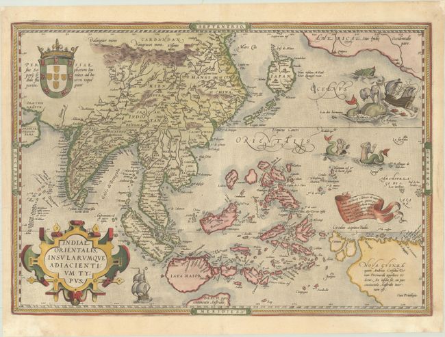
Subject: Southern & Southeast Asia
Period: 1570 (published)
Publication: Theatrum Orbis Terrarum
Color: Hand Color
Size:
19.8 x 13.8 inches
50.3 x 35.1 cm
Ortelius' important map of Southeast Asia, based on Mercator's 1569 World map, shows how sketchy the available information was concerning the region. The East Indies are presented as a randomly scattered archipelago with Java and Borneo particularly misshapen. Taiwan is mapped for the first time as I. Fermosa in the 'tail' of kite-shaped Japan's Lequaio islands. The fictitious Chyamai lacus is the source of a network of major rivers in Southeast Asia. Beach pars, a presumed promontory of the great southern continent based on Marco Polo's account, protrudes into the bottom of the map. In the upper right corner, America makes an appearance with the three coastal cities of Quivira, Cicuie, and Tiguex. Near the shore lies a ship being menaced by a pair of sea monsters, while twin mermaids preen before each other near the Ladrone Islands, which were named by Ferdinand Magellan due to an encounter with natives on the islands who attempted to steal items off Magellan's ships. Latin text on verso.
References: Van den Broecke #166; Suarez (SE Asia), pp. 164-69.
Condition: A
A crisp, early impression on a bright sheet with an eagle watermark, marginal soiling, and several small worm holes in the image at top and around the equator that have been professionally repaired with a minute amount of the image replaced in facsimile.