Catalog Archive
Auction 191, Lot 524

"Afbeeldinghe vande Vermaerde Seehaven ende Stadt van Duynkercken met der Omliggende Plaetsen Sanden ende Droochten… / Pourtraict de la Fameuse Ville et Havre de Duynckerke et Places Voisines...", Hondius, Henricus

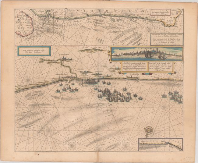
Subject: Northern France

Period: 1631 (dated)

Publication:

Color: Hand Color

Size:
20.3 x 17.2 inches
51.6 x 43.7 cm
Download High Resolution Image
(or just click on image to launch the Zoom viewer)

This impressive and uncommon sea chart depicts the coast at Dunkirk oriented with north at bottom. A few other cities are named along the coast, and the banks and shoals are shown in the sea. A large fleet of warships fills the sea. At top is an expanded chart covering the coast from Middelburg to Boulogne-sur-Mer. There is a superb inset coastal view of the city of Dunkirk and at the lower left, under the compass rose, is an inset of the coast near Calais. French text on verso, published between 1639-49, either in Nouveau Theatre du Monde or Nouvel Atlas.

References: Van der Krogt (Vol. I) #3295:1.

Condition: B+

A nice impression with contemporary color on a slightly toned sheet. There are a few light spots and a centerfold separation in the bottom margin that has been repaired on recto.

Estimate: $240 - $300

Sold for: $140

Closed on 2/8/2023

Archived