Subject: Northwestern Wales
Period: 1610 (dated)
Publication: The Theatre of the Empire of Great Britaine
Color: Hand Color
Size:
19.9 x 15 inches
50.5 x 38.1 cm
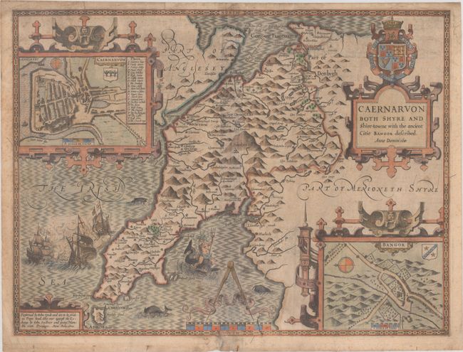
The inset of the town of Caernarvon identifies 23 locations. Superb map of Caernarvon including inset plans of Caernarvon and Bangor. The map graphically depicts the rugged countryside and is richly embellished with a sea battle, Neptune riding a sea monster and several elaborate cartouches and the royal coat of arms. John Speed is best known for this important atlas of Great Britain, which is considered the finest achievement in British map-making. Speed assembled the information for this atlas based on the work of Christopher Saxton and John Norden, updated with new information. He also introduced innovations of his own including the inclusion of town plans, indications of the hundreds, county boundaries and the coats of arms of local Earls and Dukes. The maps were finely engraved by Jodocus Hondius one of the preeminent engravers of the period. Includes the imprint of John Sudbury and George Humble. English text on verso, published between 1614-23.
References: Shirley (BL Atlases) T.SPE-1b.
Condition: B
A nice impression on a toned sheet with a bunch of grapes watermark, light soiling, scattered foxing, and some extraneous creasing. There are archival repairs to some small chips and tears along the edges of the sheet.