Subject: Central America & Colombia
Period: 1741 (circa)
Publication:
Color: Hand Color
Size:
21.3 x 16.3 inches
54.1 x 41.4 cm
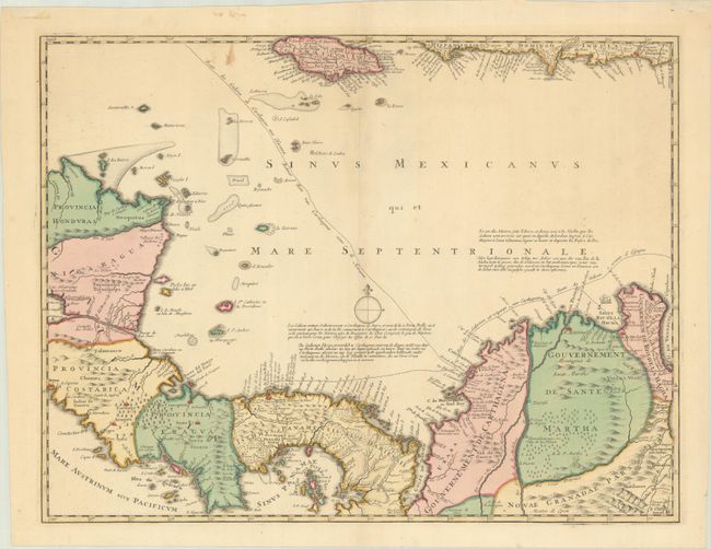
This is the south central sheet of Ottens' 6-sheet map of the Gulf of Mexico and the Caribbean depicting the theater of the War of Jenkins' Ear, part of the War of the Austrian Succession. The War of Jenkins' Ear had an improbable and theatrical origin. After fifty years of colonial boundary disputes and growing trade competition in the New World, relations between Britain and Spain were extremely strained. The war was named after Robert Jenkins, captain of the ship Rebecca, who claimed Spanish coast guards had cut off his ear in 1731. Seven years later Jenkins was invited by a party of warmongers to tell his story and display his ear to Parliament, thereby inflaming British and colonial American opinion against Spain. There was an increasing perception by the English that the Spanish were restricting their access to the slave trade in the West Indies. This friction was aggravated by a continuing dispute over the border between Spanish Florida and Georgia. These mounting issues compelled Prime Minister Walpole to declare war on Spain in October 1739.
This map depicts Panama and extends from Honduras to Colombia, and includes Jamaica and southern Hispaniola at the top. It details the major ports along the route of the Spanish treasure ships to and from Cartagena and Portobello, both shown as fortified cities. The map was first issued separately with the title Nova Isthmi Americani, qui et Panamiensis Item Dariensis, Tabula, in qua Urbes Porto Bello, Panama et Carthagena..., although this updated version features additional place names, extensive notes, and the route of Spanish galleons through the Caribbean. The Ottens' wanted to capitalize on the increased interest in the War of Jenkins' Ear, and published each sheet of the 6-sheet map as it was printed in 1740-41. The full set of 6 maps was not available until June 1741, and the individual maps were also included in made-to-order composite atlases. As a result, this map is not commonly found on the market.
References: cf. Kapp (MCC-73) #36; Phillips (Atlases) #3495-118.
Condition: B+
A crisp impression in contemporary color with a small, light stain at top.