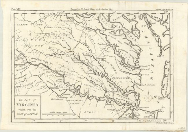
Subject: Eastern Virginia
Period: 1788 (circa)
Publication: The History of Rise, Progress and Establishment … of the United States
Color: Black & White
Size:
10.4 x 7.2 inches
26.4 x 18.3 cm
This detailed Revolutionary War map extends from tidewater Virginia back into the Piedmont to Louisa and Orange counties. Derived in part from the Fry & Jefferson map of Virginia and Maryland, it includes part of Maryland and much of the lower Chesapeake Bay. Watershed, islands, courthouses, and some early roads are delineated. It names many towns and settlements including Jamestown, Williamsburg, Norfolk, Suffolk, Hampton, Richmond, Hanover, Fredericksburg, Elk Hill, Albemarle, and Tappahannock. The map locates Tod's Bridge, Raccoon Ford, Cape Henry, Point Comfort, and more. Published in William Gordon's The History of Rise, Progress and Establishment of the Independence of the United States.
References: Howes #G-256.
Condition: A
Issued folding on a bright sheet with a few faint spots of foxing mostly in the margins. A small paper flaw in the James River near Hampton is only visible when held to light.