Subject: World
Period: 1760 (dated)
Publication:
Color: Hand Color
Size:
38.5 x 19.4 inches
97.8 x 49.3 cm
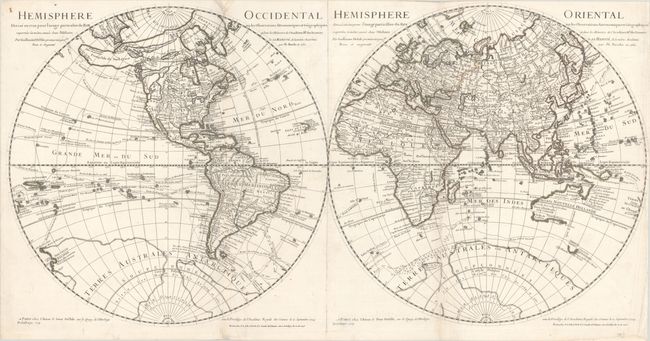
These are the updated editions of Buache's maps of the hemispheres, based on Delisle, and the only edition of this map to show a Sea of the West on the Northwest Coast of North America. There are a number of interesting geographical misconceptions on this map, primarily focused on the Pacific Northwest and in the Antarctic. A River of the West (R. de l'Ouest) empties into the Mer de l'Ouest and nearly connects to the Mississippi River. Several other potential Northwest Passages are also depicted, including Lac de Valasco, Lac de Fonte and an open-ended Grande Eau extending northeast from the Mer de l'Ouest. Alaska has a very rudimentary shape that stretches too far to the west. In the Antarctic, large landmasses named Terres Australes our Antarctiques fill the sea and connect to New Zealand. The seas are filled with the routes of explorers, including Magellan, Tasman, and Mendaña. Engraved by Delahaye. On two sheets, joined.
References: McGuirk #79; Tooley (America) p. 18, #25.
Condition: B+
Contemporary outline color on bright, watermarked sheets with light soiling and narrow margins at top and right. There are professional repairs to a small worm hole in the left blank margin, a couple of chips along the edges of the sheet, and a 1/2" x 1" worm hole near the South Pole in the eastern hemisphere with small loss of image. There is also some professional reinforcement of the folds.