Subject: Falkland Islands, South Sandwich Islands, & South Georgia
Period: 1774-78 (circa)
Publication:
Color: Hand Color
Captain James Cook (1728-1779) is best known for his three voyages to the Pacific (1768-71; 1772-75; and 1776-79). His discoveries radically changed the western understanding of the world in the late 18th century. He was the first to circumnavigate and chart New Zealand and provided the earliest European accounts of exploration along the eastern coast of Australia and the Hawaiian Islands. On February 14th, 1779, he was killed on Hawaii after attempting to kidnap the chief of the island.
Many contemporary accounts of Cook’s voyages, including charts and engravings, appeared in the late 18th century. The first official account of Cook’s first voyage was published in 1773 by John Hawkesworth in Volumes II and III of An Account of the Voyages Undertaken by the Order of His Present Majesty for Making Discoveries in the Southern Hemisphere... William Strahan and Thomas Cadell published the first official accounts of the second and third voyages in 1777 and 1784. Accounts of his exploration were subsequently translated into French, German, and Dutch.
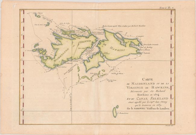
A. Carte de Maidenland ou de la Virginie de Hawkins, Decouverte par Sir Richard Hawkins en 1573, et du Canal Falkland..., from Cartes et Figures des Voyages Entrepris par Ordre de sa Majest Britannique..., published 1774 (11.8 x 8.8"). This striking chart of the Falkland Islands shows many harbors, channels, capes, bays, shoals, islands, rocks, and soundings. The title erroneously claims that Sir Richard Hawkins discovered the Falkland Islands in 1574, when he would have been twelve years old. Hawkins did map the northern coastline of what may have been the islands in 1593, but the islands appeared on charts before that date. The map identifies a rock named by Hawkins and traces the track of Capt. John Strong's exploration in 1689, when he discovered the sound in between the two main islands. This edition of the map is from Hawkesworth's Cartes et Figures des Voyages..., published by Saillant and Nyon. Condition: On a lightly toned sheet with a bunch of grapes watermark and a faint dampstain along the centerfold.
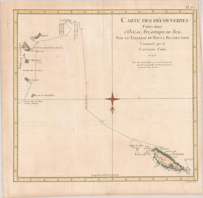
B. Carte des Decouvertes Faites dans l'Ocean Atlantique du Sud, sur le Vaisseau du Roi la Resolution..., from Voyage dans l'Hemisphere Austral ... Tome Quatrieme, published 1778 (13.2 x 12.3"). This chart details the track of H.M.S. Resolute between the South Sandwich Islands and South Georgia. Cook claimed South Georgia for the Kingdom of Great Britain, naming it the "Isle of Georgia" in honor of King George III. He named the Sandwich Islands "Sandwich Land" after the 4th Earl of Sandwich, First Lord of the Admiralty. This British overseas territory is in a remote and inhospitable portion of the southern Atlantic Ocean hundreds of miles east-south-east of Terra del Fuego. The islands are uninhabited save for a small British contingent to support the British Antarctic Survey who maintains a base at Bird Island. Argentina's claim over South Georgia contributed to the 1982 Falklands War. Condition: Issued folding, now flat, on watermarked paper with light dampstaining and minor offsetting.
References:
Condition: B+
See description above.