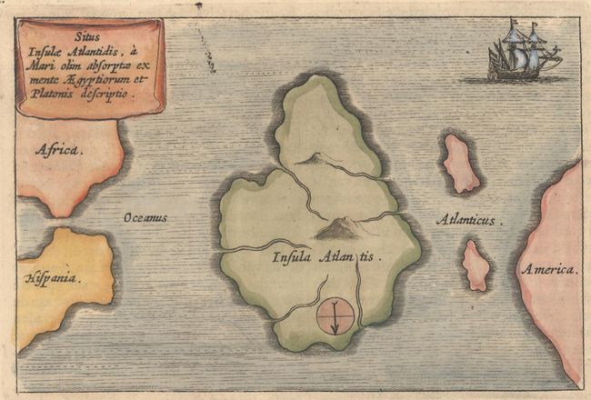
Subject: Atlantic Ocean, Atlantis
Period: 1682 (published)
Publication: D'Onder-Aardse Weereld
Color: Hand Color
Size:
6.2 x 4.1 inches
15.7 x 10.4 cm
This mythical map of Atlantis is printed with north at the bottom, leaving the coast of America to the right, and Africa and Spain on the left. The Island of Atlantis (Insula Atlantis) is a huge land mass which occupies a majority of the Atlantic Ocean. Two mountains and six rivers are depicted within the island, otherwise the interior is blank. The map is embellished with a fully ruled sea, a two masted sailing ship at upper right, a curtain-style cartouche and a simple compass rose. From Kircher's masterpiece, Mundus Subterraneus (The Underground World) which was the first serious effort to describe the physical makeup of the earth, proposing theories (sometimes fantastic) in the areas of physics, geography, geology, and chemistry. On a full sheet of Dutch text measuring 9.4 x 14.6".
References:
Condition: A
A sharp impression on a clean, bright sheet with a hint of toning.