Subject: Gulf Coast of Texas
Period: 1853-67 (dated)
Publication:
Color: Black & White
The Office of Coast Survey is the oldest U.S. scientific organization, dating from 1807 when Congress directed that a "survey of the coast" be carried out. By 1836, it was called the U.S. Coast Survey and in 1878, the name was changed to the U.S. Coast and Geodetic Survey. Today the Office of Coast Survey is a division of the National Oceanic and Atmospheric Administration NOAA.
The survey teams, composed of civilians as well as Army and Naval officers, charted the nation's waterways and produced a wide array of reports, survey charts, hydrographic studies of tides and currents, astronomical studies and observations, and coastal pilots. These charts are an important record of the changing nature of the nation's coastlines. In additional to coastal charts, the U.S. Coast and Geodetic Survey produced land sketches, Civil War battle maps, and the early aeronautical charts.
Six early Coast Survey charts showing the development of the Texas Gulf Coast in the latter part of the 19th century.
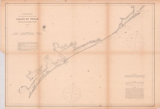
A. Coast of Texas from Galveston to Corpus Christi, dated 1867 (31.3 x 21.7"). Covers the stretch of coastline from Corpus Christi to Galveston with plenty of navigational information. Condition: Issued folding with light toning, scattered foxing, and some fold separations. There is a binding trim in the left blank margin with a 1.5" associated tear that crosses the neatline. (B)
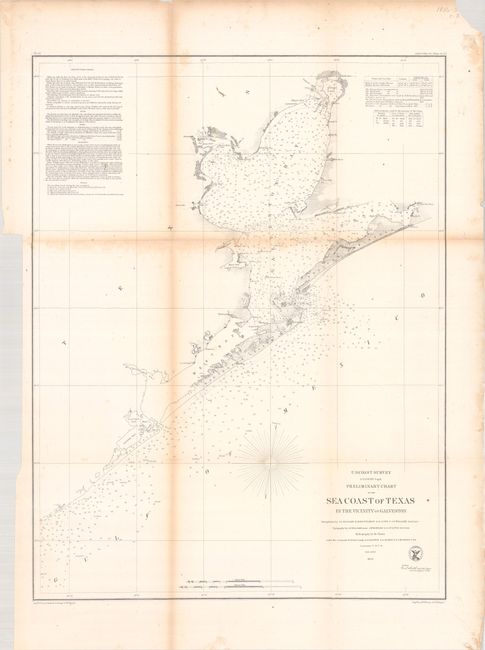
B. Preliminary Chart of the Sea Coast of Texas in the Vicinity of Galveston, dated 1856 (19.3 x 25.4"). This chart is centered on the city of Galveston, but continues northward to show the entire bay. It extends on the coast west beyond Oyster Bay, and east beyond Bolivar Peninsula to Muscle and East Bay points. Details include buoys and beacons, a light boat, shoals, reefs, and is filled with soundings, bottom types, extensive notations on sailing directions, tides, etc. In Galveston Bay, the mouth of the San Jacinto is depicted as is Turtle Bay. Condition: Issued folding with light toning along the folds, minor foxing, and a few splits along the folds. There is a binding trim in the left blank margin. (B+)
C. (Sketch I No. 3) Galveston Entrance Texas from a Trigonometrical Survey..., dated 1853 (17.0 x 13.8"). This coastal survey chart details the entrance to Galveston Bay. It includes a town plan of Galveston without streets named. The chart extends to Pelican Island, Bird Key, and Bolivar Point. It locates buoys, a beacon, a light boat, and is filled with soundings, bottom types, extensive notations on sailing directions, tides, etc. Triangulations were accomplished in 1848 by R.H. Fauntleroy and J.S. Williams, the topography was accomplished in 1849 and 1850 by J.M. Wampler, while the hydrography was under the direction of T. A. Craven and A. S. Baldwin in 1851 and 1852. Condition: Issued folding with light dampstaining, light toning along the folds, splitting along the folds, and a binding trim in the left blank margin. (B)
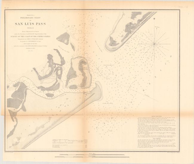
D. (Sketch I No. 4) Preliminary Chart of San Luis Pass Texas from a Trigonometrical Survey..., dated 1853 (16.9 x 13.7"). Handsome chart of the entrance to Galveston Bay, noting San Luis Island, Galveston, and Mud Island, as well as Peninsula Point. The chart notes soundings, sailing directions, and tidal effects. Condition: Issued folding with light toning along the folds, an 8.5" horizontal fold separation, and a binding trim the left blank margin. (B)
E. Sketch I No. 3 Aransas Pass Coast of Texas..., dated 1853 (8.0 x 7.4"). This small map depicts the Aransas Pass between Mustang Island and San Jose Island (to the east of Corpus Christi). Shows numerous soundings and a proposed sight for a light boat. Condition: On a lightly toned sheet with minor foxing and some edge tears that enter into map image. (B)
F. Sketch I Showing the Progress of the Survey in Section No. 9 1848 to 53, dated 1853 (21.6 x 7.6"). This chart depicts the early triangulations in and around Galveston Bay that were the basis for all later surveying in Texas. Condition: Issued folding with light uneven toning. (B+)
References:
Condition:
See description above.