Subject: Eastern United States & Canada, Franklin
Period: 1805 (circa)
Publication: Travels to the Westward of the Allegheny Mountains
Color: Black & White
Size:
13.1 x 15.9 inches
33.3 x 40.4 cm
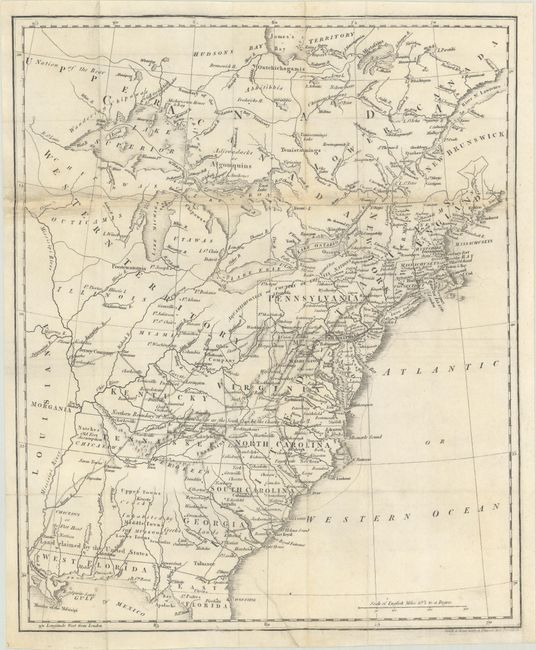
This great map of the fledgling nation includes numerous areas of interest, including the proposed state of Franklinia and the Spanish sponsored Morgania colony. In New England, Maine is shown with a truncated northern boundary, reflecting the British view of the border dispute. Georgia's western boundary is the Mississippi River. Florida, at the time a Spanish territory, is divided into East and West, with the notation "Land Claimed by the United States" on the northern boundary on the 31st parallel. A note above North Carolina and Tennessee states "Northern Boundary of North Carolina as far as the South Sea by the Charter of Charles II." The proposed state of Franklinia is located in eastern Tennassee. In 1785 settlers in present-day western North Carolina and eastern Tennessee organized a state government to be named in honor of Benjamin Franklin. Congress turned down their appeal but the fledgling state maintained a legislature and governor until 1788. To the west of the Mississippi is Morgania. This region was named after George Morgan, a land speculator, who attempted to create a new colony in the then Spanish controlled Louisiana Territory near New Madrid (Morgan gave up this endeavor a few years later).
This untitled map is similar to Phillips' Map of the United States, Canada the River St. Lawrence, the Lakes &c. (1801), but the plate has been improved with additional place names and rivers and a re-engraved Yazoo River. It appeared in Francois Andre Michaux's Travels to the Westward of the Allegheny Mountains, published by Phillips in 1805 and Crosby in 1806. Engraved by Smith & Jones.
References: Dotson & Baker (OWA) #14b.1; cf. Baynton-Williams #11i.
Condition: B
A nice impression issued folding, now flat, on a sheet with an "1808" watermark. There is a repaired edge tear at bottom that extends 1.5" into the image and a number of small chips along the top horizontal fold that have been infilled, with small areas replaced in facsimile. Remargined at right with a portion of the border in facsimile.