Subject: Texas & New Mexico
Period: 1854-56 (dated)
Publication: U.S. Pacific Railroad Surveys
Color: Black & White
Size:
56.8 x 27.5 inches
144.3 x 69.9 cm
During the 1850s, the U.S. government sponsored an extensive series of expeditions designed to gather information on the vast new territories that had been acquired in western North America. The discovery of gold in California further stimulated westward traffic and heightened the need for a faster and more convenient way to bring the far-flung parts of the country together. In 1853 Congress commissioned the Army's Topographic Bureau to conduct a series of surveys to find a suitable route for a transcontinental railroad. There were six major expeditions; five of them covered the area between the Great Plains and west coast, and the sixth explored the coastal states of California and Oregon. All of these expeditions were accompanied by naturalists and artists to document the landscape, flora and fauna along the route.
The reports, maps and lithographs were published in the 13 volume report "Explorations and Surveys to ascertain the most practicable and economical route for a Railroad from the Mississippi river to the Pacific Ocean."
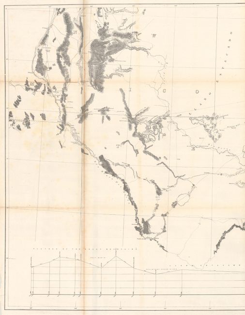
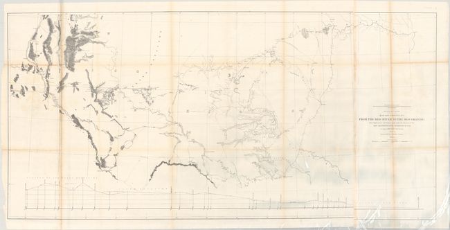
This map extends from San Antonio and Dallas west to Las Cruces and Fort Craig in New Mexico Territory. Pope's numerous exploration routes and camps are shown on both sides of the 32nd parallel. The map includes good detail of topography and the river systems, and locates numerous forts, ruins, springs, river crossings, and mines. A profile at bottom shows the elevation change from the Red River to El Paso. The map is encased in Mylar for preservation.
References: Wheat (TMW) #898.
Condition: B+
Issued folding with some light toning along the fold lines, faint scattered foxing, and a couple of short fold separations. There is a bit of glare in the image along the lower sheet edge that is caused by our scanner and is not on the physical map.