Subject: Southwestern United States, Mexico & Central America
Period: 1834 (dated)
Publication: Atlas Universel...
Color: Hand Color
Size:
15.8 x 12.1 inches
40.1 x 30.7 cm
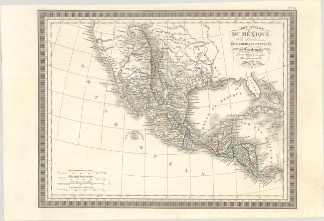
This attractive French atlas map covers the Southwestern United States, Mexico, and Central America. The Southwest is still under Mexican control, including Texas, which is shown in a squat configuration. Nouveau Mexique is a narrow strip of land that includes Sante Fe, Taos, and Albuquerque. In between California and the lakes Timpanogos and Teguayo is an area labeled Pays inconnu. Two conjectural rivers, R. S. Sacramento ou Timpanogos and R. S. Buenaventura extend from Timpanogos and Teguayo to the Pacific Ocean. Another conjectural river, the Martires, flows parallel to the Colorado. The Gila River is inaccurately depicted as emptying into the Gulf of California. Political divisions are delineated in Mexico, and there are plenty of place names all the way south to Panama. While the map extends as far east as Florida, the area east of the Mississippi is left mostly blank. Four distance scales. Surrounded by a keyboard-style border.
References: Phillips (Atlases) #767a-34.
Condition: A
Near fine with minor spots.