Subject: Arctic & Scandinavia
Period: 1579 (published)
Publication: Le Miroir du Monde
Color: Hand Color
Size:
4.2 x 3.1 inches
10.7 x 7.9 cm
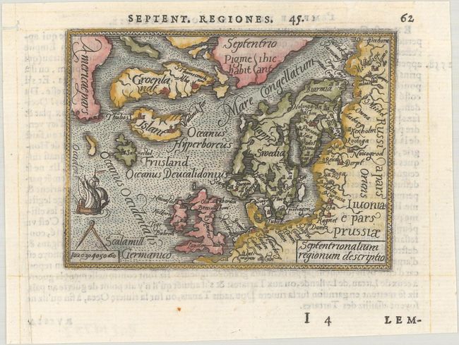
Delightful miniature map based on Ortelius' important map of the Arctic regions and the North Atlantic with the mythical islands of Drogeo (unnamed) and Friisland. Greenland is shown as a large island separated from the Pigme Ihio Habitant (land in habited by pigmies). French text on verso.
This map is from the first pocket-sized atlas, Spieghel der Wereld, which was based on Ortelius' Theatrum Orbis Terrarum. The maps were engraved on copper by Filips Galle and represented all regions around the world. The maps were accompanied by text prepared by Peter Heyns, who used the text from the Theatrum. The numbers printed above the maps, adjacent to the letterpress title, indicate the number of the map within the Theatrum. This innovative, small atlas was designed to reach the lower middle class, and was a commercial success, prompting numerous reprints and imitations. The first edition of the Spieghel der Wereld was published in 1577, with subsequent editions published in French in 1579 and 1583, Dutch in 1583 and 1596, and Latin in 1585. One unique feature of this pocket atlas was the inclusion of 6 larger, fold-out maps of the world, Europe, France, Germania, the Low Countries and Italy that were included alongside 66 miniature maps.
References: King (2nd Ed.) pp. 60-61; Van der Krogt (Vol. III) #1200:331.
Condition: A
A crisp impression on a bright sheet with a tiny worm track at lop left and several professionally repaired worm tracks at top right, none of which enter the image.