Subject: United States, Texas
Period: 1848 (dated)
Publication:
Color: Hand Color
Size:
33.3 x 13.6 inches
84.6 x 34.5 cm
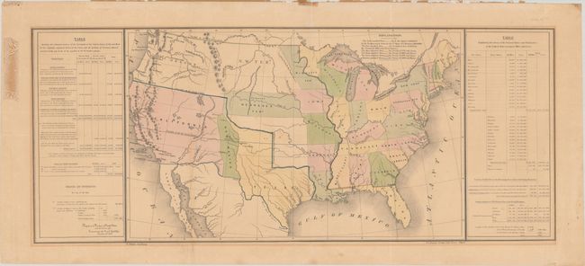
This map shows the new state of Texas with its northern boundary extending to 42 degrees N. latitude. Additional transitional territorial configurations are depicted, including a large California Territory extending nearly to Texas with a small version of New Mexico sandwiched in between. Within California are early references to the gold-related Nueva Helvetia and Sutter's Fort. Sometimes referred to as the 'Tables Map' because a table on each side of the map offers selected statistical information including details on the "Three Divisions" of Texas. The map contains interesting versions of treaty boundaries drawn and a table of explanations provides treaty dates. Wheat says the map was likely prepared for the General Land Office to show 1848 Guadeloupe-Hidalgo treaty lines. Hand coloring is used to indicate other treaty boundaries including Great Britain 1783; Spain 1795; France 1803; Spain 1819; Great Britain 1842 & 1846; and Mexico 1848. Lithographed by Duval in Philadelphia.
References: Streeter Sale (Vol. 6) #3876; Wheat (TMW) #561.
Condition: B
Issued folding with light toning, a few spots of foxing, and a bit of mat burn along the borders. There are remnants of paper tape along the top sheet edge and staining in the left side margin from masking tape on verso (all far from image).