Subject: Northern & Central Asia
Period: 1610-1712 (circa)
Publication:
Color: Hand Color
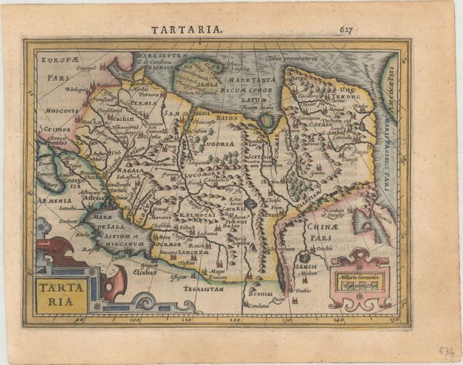
A. Tartaria, by Mercator/Hondius, from Atlas Minor, circa 1610 (7.4 x 5.5"). This handsome small map depicts the northern region of Asia fully engraved with mountains, forests, and towns. It includes part of China and the island form of Korea. The Anian Fretium separates Asia from Americae Pars. The map features strapwork title and scale of miles cartouches. Latin text on verso, published between 1610-1621. References: Moreland & Bannister, p. 98; Van der Krogt (Vol. III) #8050:351. Condition: A crisp impression with a hint of toning.
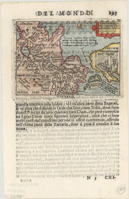
B. Tartariae sive Magni Chami Regni Tipus, by Ortelius/Marchetti, from Il Theatro del Mondo, published 1667 (4.1 x 2.9"). While designed to illustrate the expansive kingdom of the Great Khan in Asia, this tiny map's main feature is the Stretto di Anian separating Asia and North America based on the theory of Giacomo Gastaldi. Near the southern entrance to this strait is a large and strangely shaped Japan with a notation concerning the writings of Marco Polo. In North America, the Sierra Nevadas are named in California, as are five of the mythical cities of Cibola. Pietro Maria Marchetti produced the second pocket atlas based on Abraham Ortelius' folio Theatrum. It is often referred to as the plagiarized version of the Epitome. The copper plates are closely copied from those of Philip Galle's 1593 Italian edition. On a full sheet (5.5 x 7.5") of Italian text below map and on verso. References: Burden #128; King (2nd ed.) pp. 78-79. Condition: On watermarked paper with show-through of text on verso.
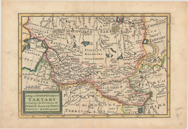
C. A Map of Independent Tartary Containing the Territories of Usbeck, Gasgar, Tibet, Lassa &c., by Herman Moll, from Atlas Geographicus, published 1712 (10.1 x 7.0"). This uncommon small map covers the region from the Caspian Sea to the Great Wall of China, with the mythical Chamay Lake depicted at bottom. The region is mostly the domain of the Kalmyk people with various areas denoted for Black Kalmucks, Fugitive Kalmucks, Brown Kalmucks, etc. Other kingdoms include the Usbeck, Gasgar, Great Tibet and Lassa or Boutan. Reference: Shirley (BL Atlases) T.MOLL-3a #66. Condition: A nice impression with a hint of toning.
References:
Condition: A
See description above.