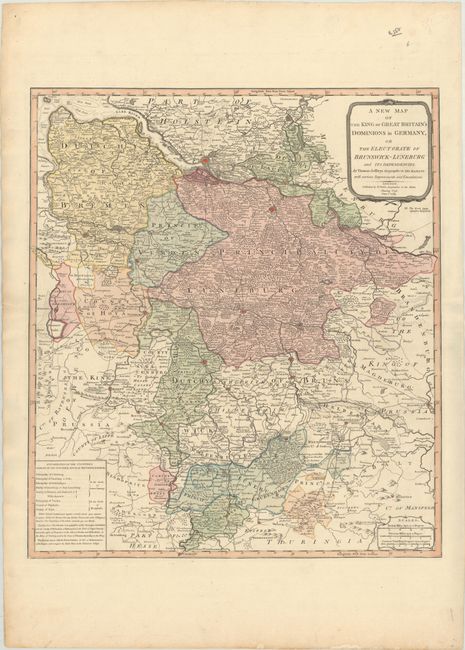
Subject: Northwestern Germany
Period: 1789 (dated)
Publication: General Atlas
Color: Hand Color
Size:
20.8 x 23.6 inches
52.8 x 59.9 cm
Thomas Jefferys was one of the most important English map publishers of the 18th century. His work included prints and maps of locations around the world, but his most notable maps are of North America and the West Indies. He began his career in the map trade in the early 1730s, working as an engraver for a variety of London publishers, and eventually setting up his own shop. In 1746, he was appointed Geographer to the Prince of Wales, and in 1760 he became Geographer to the King. These titles granted access to manuscripts and cartographic information held by the government. In the early 1760s he embarked on an ambitious project to produce a series of English county maps based on new surveys, but ran out of money and filed for bankruptcy in 1766. He then partnered with London publisher Robert Sayer, who reissued many of Jefferys plates and continued to issue new editions after Jefferys' death in 1771. Jefferys' American Atlas and the accompanying West-India Atlas, published post posthumously, are considered his most important cartographic works.
This large-scale map focuses on present-day Lower Saxony, extending from Hamburg in the north to Kassel in the south. The map is filled with cities, roads, political boundaries, rivers, forests, mountains and marshes. The region was at the time known as the Duchy of Brunswick-Lüneburg, which was ruled by King George III as part of the Holy Roman Empire.
References:
Condition: A
There is a short edge tear confined to the bottom blank margin, far from the map image.