Subject: Africa
Period: 1705 (published)
Publication: Algemeene Weereld-Beschryving...
Color: Hand Color
Size:
10.8 x 7.7 inches
27.4 x 19.6 cm
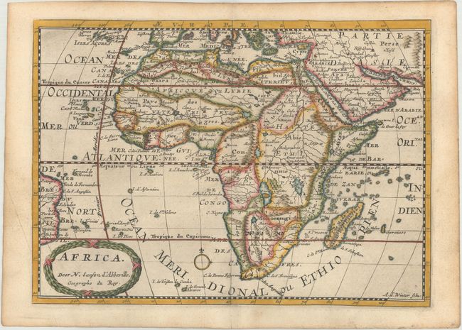
Attractive and detailed map of Africa that includes the Arabian Peninsula, the Canary and Cape Verde Islands, Madagascar, as well as several other islands and a little of the coastline of Brazil. The Nile originates in two, spurious large lakes just north of the fictional Monts de la Lune. The title is enclosed in a wreath-style cartouche. Engraved by Antoine d' Winter. This map appeared in Algemeene Weereld-Beschryving, nae de Rechte Verdeeling der Landschappen, Plaetsen, Zeeën, Rivieren, &c. Geographisch, Politisch, Historisch, Chronologisch en Genealogisch, a Dutch edition of A. Phérotée de la Croix's Nouvelle Methode Pour Apprendre Facilement la Geographie Universelle, which first appeared in 1690. The Dutch edition was published by Francois Halma and included 98 maps and views.
Sanson's small maps from his L'Afrique en Plusieurs Cartes..., first published in 1656 and engraved by A. Peyrounin, were copied several times by various map publishers. Johann David Zunners made copies of Sanson's maps for his German translation of Die Gantze Erd-Kugel in 1679. Johannes Ribbius and Simon de Vries published copies in 1682 and 1683, with new maps engraved by Antoine d'Winter. The plates were later sold to Francois Halma, who used them in 1699 and then again in 1705 with the titles re-engraved in Dutch. The titles on the d'Winter plates were re-engraved back into French, and then used by Nicholas Chemereau in 1715 and by Henri du Sauzet in 1738.
References:
Condition: A
A dark impression on paper with a large fleur-de-lis coat of arms watermark and light toning along the edges of the sheet.