Subject: Holy Land
Period: 1545 (circa)
Publication: Geographia
Color: Hand Color
Size:
13.6 x 10 inches
34.5 x 25.4 cm
Sebastian Munster (1489 - 1552) was one of the three most renowned cartographers of the sixteenth century, along with Mercator and Ortelius. Munster's Geographia and Cosmographia Universalis were two of the most widely read and influential books of the period. His editions of Ptolemy's Geographia, published between 1540 and 1552, were illustrated with 48 woodcut maps, the standard 27 Ptolemaic maps supplemented by 21 new maps. These new maps included a separate map of each of the known continents and marked the development of regional cartography in Central Europe. The antique geography was a prelude to Munster's major work, the Cosmographia, which was published in nearly 30 editions in six languages between 1544 and 1578 and then was revised and reissued by Sebastian Petri from 1588 to 1628. The Cosmographia was a geographical as well as historical and ethnographic description of the world. It contained the maps from the Geographia plus additional regional maps and city views with nearly 500 illustrations which made it one of the most popular pictorial encyclopedias of the sixteen century.
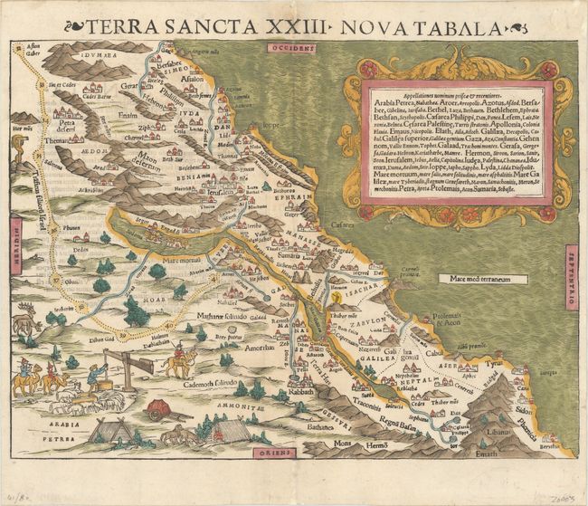
Munster based this map of the Holy Land on maps by Mercator and Ziegler and filled it with numerous woodcut vignettes. The unusual orientation of the map places west at the top with the coastline running southwest to northeast. The shoreline is remarkably accurate for the period, covering from Sidon and the land of the Phoenicians in the north, to Gaza in the south. The last nine encampments of the wandering Israelites during the Exodus are shown along with the tribal divisions. The cartouche contains an index of place names that appear on the map with each boldfaced entry followed in italics by the alternative names by which the site was known. Published in the 1545 or 1552 editions of Munster's Geographia.
References: Laor #526; Mickwitz & Miekkavaara #213-51.
Condition: A
An excellent impression on a bright sheet with several small worm tracks confined to the blank margins that have been professionally infilled.