Subject: Southern South America
Period: 1775 (dated)
Publication: A Voyage Towards the South Pole, and Round the World
Color: Hand Color
Size:
19.9 x 16.9 inches
50.5 x 42.9 cm
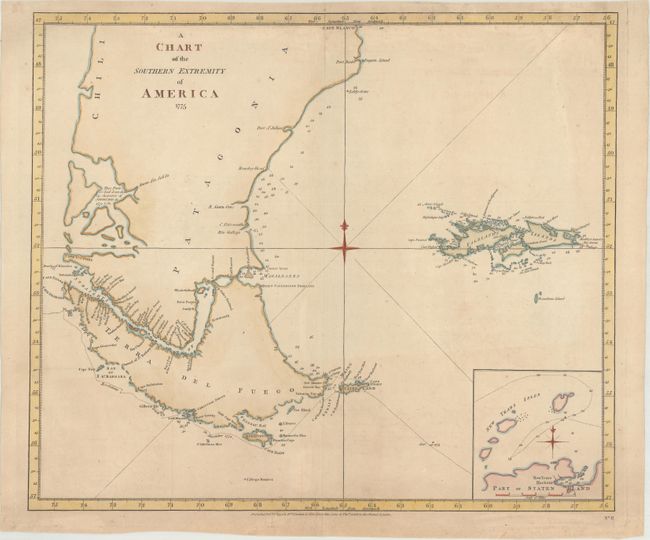
Captain James Cook (1728-1779) is best known for his three voyages to the Pacific (1768-71; 1772-75; and 1776-79). His discoveries radically changed the western understanding of the world in the late 18th century. He was the first to circumnavigate and chart New Zealand and provided the earliest European accounts of exploration along the eastern coast of Australia and the Hawaiian Islands. On February 14th, 1779, he was killed on Hawaii after attempting to kidnap the chief of the island.
Many contemporary accounts of Cook’s voyages, including charts and engravings, appeared in the late 18th century. The first official account of Cook’s first voyage was published in 1773 by John Hawkesworth in Volumes II and III of An Account of the Voyages Undertaken by the Order of His Present Majesty for Making Discoveries in the Southern Hemisphere... William Strahan and Thomas Cadell published the first official accounts of the second and third voyages in 1777 and 1784. Accounts of his exploration were subsequently translated into French, German, and Dutch.
This is the first state of this interesting copper-engraved sea chart that was published by William Strahan and Thomas Cadell. It traces Captain Cook's track around Cape Horn on the Resolution in the winter of 1774-75. There is good detail along coastlines complete with soundings. It includes the Falkland Islands and an inset of "Part of Staten Land."
References: Shirley (BL Atlases) G.COOK-1a #13.
Condition: B+
Very minor toning and soiling with one tiny tear in the top blank margin that just enters the map border.