Subject: Jacksonville, St. Augustine & Florida Keys
Period: 1856-62 (dated)
Publication:
Color:
The Office of Coast Survey is the oldest U.S. scientific organization, dating from 1807 when Congress directed that a "survey of the coast" be carried out. By 1836, it was called the U.S. Coast Survey and in 1878, the name was changed to the U.S. Coast and Geodetic Survey. Today the Office of Coast Survey is a division of the National Oceanic and Atmospheric Administration NOAA.
The survey teams, composed of civilians as well as Army and Naval officers, charted the nation's waterways and produced a wide array of reports, survey charts, hydrographic studies of tides and currents, astronomical studies and observations, and coastal pilots. These charts are an important record of the changing nature of the nation's coastlines. In additional to coastal charts, the U.S. Coast and Geodetic Survey produced land sketches, Civil War battle maps, and the early aeronautical charts.
This lot includes 3 U.S. Coast Survey charts of Florida. Each features navigational information including depth soundings, hazards, bottom types, tide charts, and more.
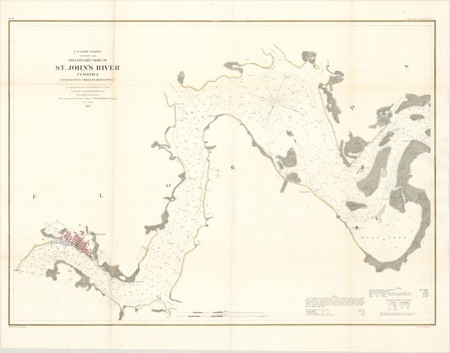
A. Preliminary Chart of St. John's River Florida from Brown's Creek to Jacksonville, dated 1856, hand color (27.2 x 19.4"). This handsome chart follows the St. John's River from Jacksonville to Mill Cove. Jacksonville is shown in miniature plan form. Newcastle, Pauline, Marian, Radcliffe, and Reed islands are named.
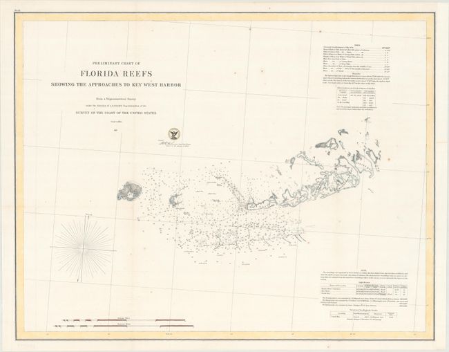
B. Preliminary Chart of Florida Reefs Showing the Approaches to Key West Harbor, dated 1857, hand color (22.7 x 17.8"). This chart zooms in on the westernmost Florida Keys, spanning from Cudjoe Key across the Boca Grande Channel to Marquesas Keys. There is little inland detail, but the waters surrounding the key are dense with navigational information. Three lighthouses are located.
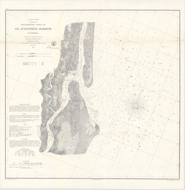
C. Preliminary Chart of St. Augustine Harbor Florida, dated 1862, black & white (21.4 x 20.7"). This intricately detailed coastal chart centers on St. Augustine, shown here in miniature plan form. The chart extends to include the northern part of Anastasia Island and Vilano Beach, here labeled North Beach. There is terrific topographical detail on land. It identifies Fort Marion, the St. Augustine Lighthouse, and the Tolomato and Matanzas rivers.
References:
Condition: A
Issued folding, now flattened and professionally backed in archival tissue to repair a number of fold separations and small holes with a minute loss of image. There is a hint of toning along several folds. The chart of the Florida Keys has a few spots of foxing and the right margin has been extended.