Subject: Western Hemisphere - America
Period: 1658 (circa)
Publication:
Color: Hand Color
Size:
20.1 x 15.6 inches
51.1 x 39.6 cm
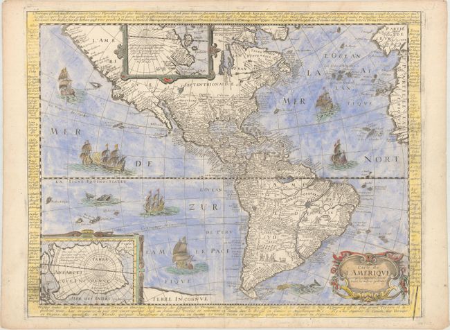
Very rare derivative of Petrus Bertius' 1624 map of the Americas, which in turn was derived from Hondius' influential map of 1618. Although Berey's name does not appear on the map, it was identified as being part of a set of four matching maps of the continents, of which the maps of Europe and Asia include Berey's imprint. The unique factor on Berey's set of continents are the panels of text surrounding the maps that give information on the continent, including the principal towns, rivers, and islands. Geographically, the map shows the northwest coast of North America slanting to the west with numerous place names. There is not a lot of detail along the eastern coast in the mid-Atlantic region. In the Southwest the famous seven cities of Cibola appear on the banks of a large spurious lake. In South America, the mythical Parime Lac appears as a large inland sea in Guiana and there are two engraved scenes, one detailing a cannibalistic feast and the other showing a mythical giant of Patagonia. Two stylized insets of the polar regions are enclosed in strapwork cartouches; the North Pole depicts Frobisher's theory of the Northwest Passage and the South Pole shows the long-held notion of the mythical southern continent. The map is finely ornamented with galleons, sea monsters, and a strapwork title cartouche.
References: Burden #328.
Condition: A
A clean and bright example with later coloring, a visible crack in the plate at bottom right, and some minor pencil markings in the bottom blank margin.