Subject: Northern Africa
Period: 1578 (published)
Publication: Tabulae Geographicae Cl. Ptolemaei...
Color: Hand Color
Size:
18.8 x 13.3 inches
47.8 x 33.8 cm
Claudius Ptolemy was a mathematician, astronomer and geographer who worked in Alexandria, then a part of the Roman Empire, in the 2nd century AD. One of the most learned and influential men of his time, his theories dominated both astronomy and geography for nearly 1500 years. His writings were kept alive by Arabic scholars during the Middle Ages and reemerged in Europe during the Renaissance. The birth of printing led to wide dissemination of his great works on astronomy and geography. There were a number of editions of his Geographia beginning in 1477. These early editions contained maps based on his original writings, known as Ptolemaic maps. As geographic knowledge increased with the explorations of Columbus, Magellan, Cabot and others, maps of the New World were added, and maps of the Old World were revised. Ptolemy's Geographia continued to be revised and published by some of the most important cartographers including Martin Waldseemuller, Sebastian Munster, Giacomo Gastaldi, Jodocus Hondius, and Gerard Mercator (whose last edition was published in 1730).
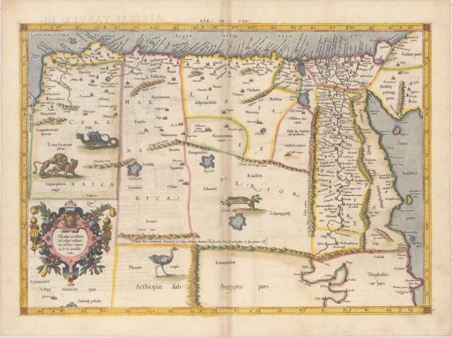
Great Ptolemaic map of eastern Libya and Egypt with numerous ancient place names, particularly along the course of the Nile. The interior is filled with fanciful animals and monsters including a superb dragon. This example was published in the very first edition of Mercator's interpretation of Ptolemy's great Geography. This is also the first state of this map, with the original cartouche at lower left, which was re-engraved in 1695. Latin text on verso with an alternate title: Africae Tabula III Continet Cyrenaicam & Aegyptum...
Although Mercator is most renowned today for the projection he popularized and for first using the term Atlas for a collection of maps, he devoted much of his life to his Ptolemaic maps. The maps were beautifully engraved as nearly as possible to their original form and embellished with fine cartouches.
References: Mickwitz & Miekkavaara #221-15; Van der Krogt (Vol. I) #0913:1.1.
Condition: B+
Light offsetting with moderate toning along the centerfold and minor marginal soiling. Remnants of hinge tape on verso.