Catalog Archive
Auction 165, Lot 660

Scarce Italian Map of the Chinese Empire

"Il Regno della China detto Presentemente Catay e Mangin, Diviso Sopra le Carte piu Esatte nelle sue Principali Provincie...", Cantelli da Vignola/de Rossi

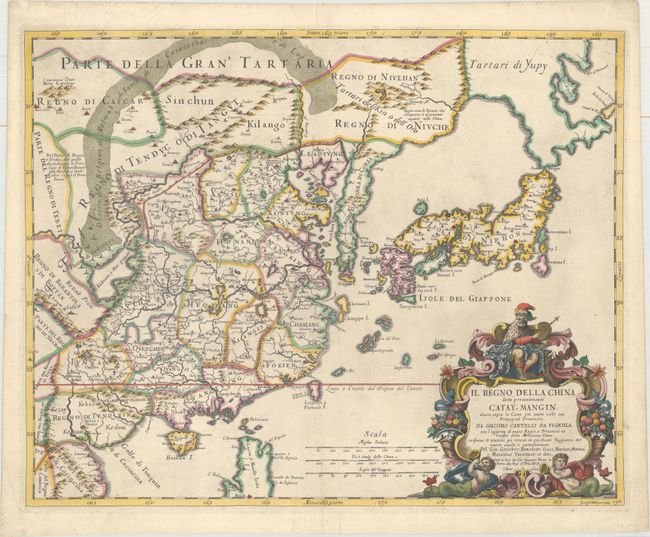
Subject: China, Korea & Japan

Period: 1682 (dated)

Publication: Mercurio Geografico

Color: Hand Color

Size:
21.6 x 17.3 inches
54.9 x 43.9 cm
Download High Resolution Image
(or just click on image to launch the Zoom viewer)

This superb map of the Chinese Empire is drawn largely from the Blaeu map compiled by Jesuit Father Martino Martini who traveled through the region between 1643 and 1650. Individual provinces, towns, and the Great Wall are depicted in China. Korea is shown as a long, narrow peninsula, and Japan is beginning to take shape, although Hokkaido is connected to Tartary and labeled Tartari di Yupi. The Dutch settlement of New Zealand is shown in Taiwan. The map extends south to include the northern part of the Philippine Island of Luzon and the city of Manila. The title cartouche features a royal figure, mermen, and cornucopias. Engraved by Giorgio Widman.

References: Shirley (BL Atlases) T.ROSS-1a #43.

Condition: A

A sharp impression on watermarked paper that has been cleaned and sized, with an expertly repaired centerfold separation at bottom.

Estimate: $1,800 - $2,100

Sold for: $1,300

Closed on 11/15/2017

Archived