Subject: Colonial North America
Period: 1696 (dated)
Publication: Atlas Nouveau
Color: Hand Color
Size:
34.4 x 21.4 inches
87.4 x 54.4 cm
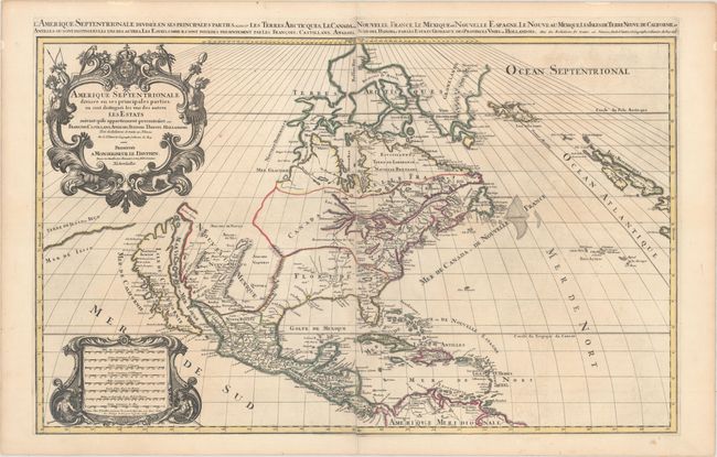
This beautiful map of the Americas shows California as an island in the style of the second Sanson model (1656) with the indented northern coastline. A small peninsula Agubela de Gato is the only part of the Pacific coastline shown north of California. A strip of Terre de Iesso ou Ieco is shown in the Pacific immediately west of northern California. Santa Fe is shown along the R. del Norte (Rio Grande River), but the river erroneously drains into the Gulf of California. The two western Great Lakes are open-ended, and Lake Erie is too far south, split by the 40th parallel. The eastern part of the continent is divided into Nouvelle France and Floride with Virginia, New Sweden, New Amsterdam and New England hugging the coast. The decorative title cartouche is adorned with the arms of the Dauphine, two natives and tropical birds. This is Mortier's edition of Jaillot's map, in which Mortier purposely omitted his imprint and indicated the map was published in Paris (despite having been engraved and printed in Amsterdam) in order to capitalize on the popularity of Jaillot's Atlas Nouveau. Second state, dated 1696. Printed on two sheets, joined.
References: Burden #686; cf. McLaughlin #55; cf. Wheat (TMW) #58; cf. McCorkle #674.3.
Condition: A
A sharp, dark impression with original outline color, very minor offsetting, and a couple of unobtrusive spots. There is an archivally repaired tear confined to the bottom blank margin.