Subject: Western Hemisphere - America
Period: 1850 (circa)
Publication: Illustrated Atlas and Modern History of the World
Color: Hand Color
Size:
9.5 x 14.1 inches
24.1 x 35.8 cm
The maps from The Illustrated Atlas were first published in serial form to a target audience that led insular lives due to the expense and hardship of travel. All that changed as the progress of the nineteenth century brought swift and dramatic changes in public awareness of far away places. Tallis' maps no doubt played an important role in this dramatic awakening. These maps not only provided up-to-date geographical knowledge, but also used vignette views within the map's design to show the native people and their occupations, cities and points of interest. The maps hark back to a cartographic tradition from the Dutch mapmakers of the seventeenth century with finely engraved decorative borders. The maps were drawn and engraved by John Rapkin with views drawn and engraved by a number of prominent artists. The maps were issued as a complete volume from 1851 until about 1865. Some of the maps were also published in other history books published by Tallis including British Colonies and, without the vignettes, in geographical dictionaries and encyclopedias until about 1880.
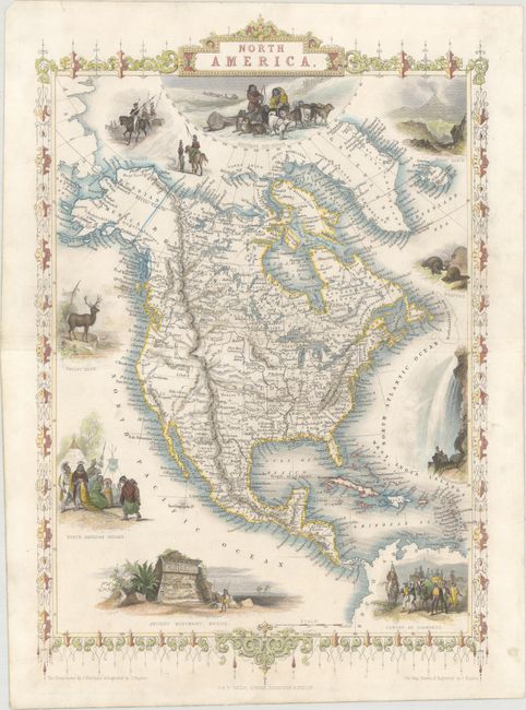
A. North America. This is an uncommon issue of this decorative steel engraved map that features Texas shown with an enlarged panhandle that extends into New Mexico and Colorado. The boundary between Canada and the United States reflects British claims in the Oregon Territory with a line fixing the boundary south of the Columbia River. Mexico is still in control of California and the Southwest. The map is filled with forts and locates many Indian tribes. Alaska is Russian America. Several lovely vignettes appear around the continent, including Wapiti Deer, Beavers, North American Indians, Ancient Monument, Mexico, and Convoy of Diamonds. Across the top are images of Russian Cossacks (representing the Russian Possessions in Alaska), an Eskimo dog sled, and Mount Hekla, Iceland. Condition: Clean and bright with light, marginal soiling. (A)
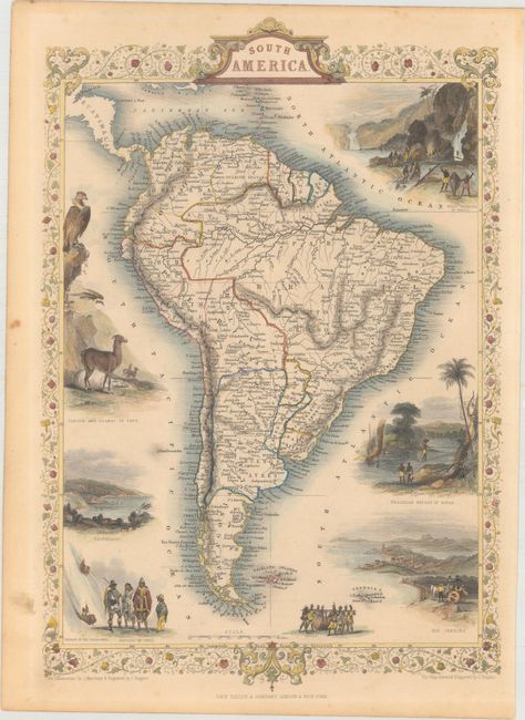
B. South America. This is a very lovely and well-engraved map of South America. It is filled with detail, including rivers, lakes, towns and villages and many place names along the coast. The continent is surrounded by eight vignettes and a decorative border and title cartouche. The vignettes shows gold mining in Brazil, condors and llamas of Peru, natives of Chili, Valparaiso, and a view of Rio de Janeiro. The map of South America is accompanied by a sheet of text describing the continent. Condition: Light toning and marginal soiling. (B+)
The vignettes surrounding these decorative maps were drawn by J. Marchant and engraved by J. Rogers. The maps were drawn and engraved by John Rapkin.
References:
Condition:
The maps are in original outline color with later coloring in the decorative vignettes. See description above for additional details.