Subject: Western Hemisphere - America
Period: 1616 (circa)
Publication: Tabularum Geographicarum Contractarum…
Color: Hand Color
Size:
5.3 x 3.8 inches
13.5 x 9.7 cm
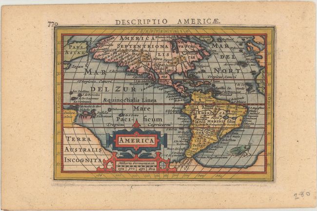
An uncommon miniature map of the Americas based on the 1606 map of America by Jodocus Hondius senior, but with the addition of the recent discovery of Hudson Bay. This small map marks the first appearance of Hudson Bay on a continental map, named here as Fretum Hudsonium. North America is shown with a large westward bulge, and the continent is filled with place names. The western coast has more names than the eastern coast, including Anian, Quivira, Tolm, Chuchuco and many others. Virginia, Florida, Chesepiook and St. Augustine are the only names on the East Coast. South America features the fictitious lake on the Equator, with the city of Manoa above, and the southern tip of the continent is nearly joined with the large, mythical southern continent of Terra Australis Incognita. New Guinea is shown attached to this large continent, and a portion of Japan and Asia appear above. The map is graced with an elaborate strapwork cartouche that incorporates the distance scale, and a whiskered sea monster swims off the coast of South America. Latin title page on verso.
References: Burden #183; King (2nd ed.) pp. 96-99; Van der Krogt (Vol. III) #9000:342.
Condition: A
A sharp impression on paper with a Strasbourg Bend watermark and light marginal toning.