Subject: Texas
Period: 1867-85 (circa)
Publication:
Color: Hand Color
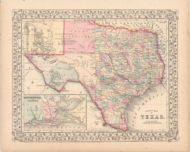
A. County Map of Texas, by Samuel Augustus Mitchell, dated 1867 (13.6 x 10.9"). One of the most attractive maps of the state of Texas, inset with a map of Galveston Bay, and Vicinity. West Texas is made up of Young Territory, Bexar Territory, El Paso and Presidio counties, and clearly shows the Llano Estacado or Staked Plain with a notation about the region being "destitu[t]e of both wood and water." Erath County is mistakenly identified as "Earth" County. The map shows trails, roads, a limited railroad system that extends only into Brenham, and proposed railroads indicated by dashed lines. The map is surrounded by a fine floral border. County development is up-to-date for 1864 as Dawson County, abolished in 1866, is included. Condition: There is one small stain at bottom and light toning along sheet edges. (B+)
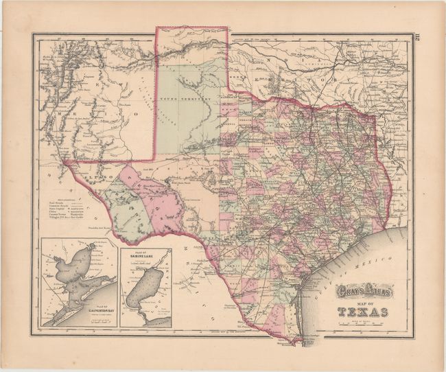
B. Gray's Atlas Map of Texas, by O.W. Gray, circa 1873 (14.8 x 12.6"). This handsome map is filled with detail and includes insets of Galveston Bay and Sabine Lake. There is a large secondary Bexar region in the West that is yet to be subdivided into counties. The huge unorganized Young Territory fills the panhandle; in fact the area was subdivided into more than 50 new counties that year. Curiously Greer County is shown as part of Indian Territory, which didn't happen until 1896. Gray's Map of Arkansas is on verso. Condition: There is a bit of toning confined to the sheet edges. (A)
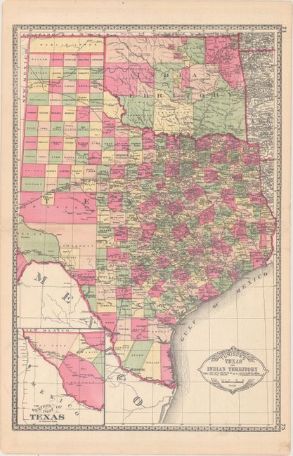
C. Tunison's Texas and Indian Territory, by H.C. Tunison, circa 1885 (13.0 x 19.6"). In Tunison's style, this is a finely lithographed map with original bright coloring. By this period most mapmakers had adopted printed color rather than the more labor intensive hand coloring employed here. It is decorated with a Victorian style border and title cartouche, which gives the population of Texas as 1,591,749 and no population reported for Indian Territory. At lower left is an inset "The Western Part of Texas on Reduced Scale." The panhandle of Oklahoma is Public Lands. Indian Territory is clearly divided into about 20 different Indian lands. Green County, originally established in 1860, is here unnamed and still part of Texas. It was abolished and awarded to Indian Territory by a Supreme Court decision in 1896. There is good detail of railroads with all stops located and named. Tunison's maps were printed on both sides; on the verso are single-page maps of Nebraska and Alabama. Condition: Clean and bright with a few tiny edge tears confined to the right blank margin. (A)
References:
Condition:
See description above.