Subject: Texas
Period: 1856 (dated)
Publication: A New Universal Atlas
Color: Hand Color
Size:
15.8 x 13.1 inches
40.1 x 33.3 cm
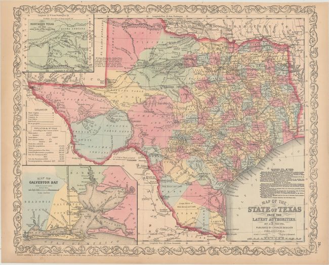
This handsome and uncommon map is a derivative of Young’s influential map of the young state of Texas, published by Charles Desilver. The organized counties extend only to Cooke in the north and Kinney in the southwest. The western edge of the frontier is marked with a line of army forts separating the settled region from the vast area noted as rolling table lands and desolate plains Destitute of Timber, that is largely the range of Apache, Kiowa, Comanche, and Lipan Indians. Wagon roads, springs, and trails are identified, including the Apache Trail, Comanche War Trail, Connelly's Trail and Emigrant's Route. Interesting place names and notations include Grand Indian Crossing, Large Droves of Wild Horses and Cattle, Howard's Spring, Pecos Ferry (on the Pecos River), Horsehead Crossing, etc. Descriptive explanations and notes make this map an interesting study. A table provides statistics according to the Census of 1850 including the population by ethnic groups, e.g. "Free Colored males" is given as 171. There are insets of Northern Texas, noting the northern boundary at Lat. 36° 30', as resolved in the Compromise of 1850, and of the vicinity of Galveston City. County lines are current to 1856 with the recent additions of Young, Brown, and McCulloch counties along the frontier.
References: Day, p. 63.
Condition: A
Original color with a few faint spots and light toning confined to sheet edges.