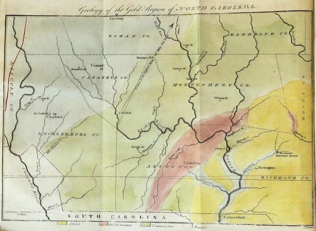
Subject: Western North Carolina
Period: 1829 (published)
Publication:
Color: Hand Color
Size:
10.8 x 7.3 inches
27.4 x 18.5 cm
This is one of the more difficult to find American Journal of Science volumes because it contains Elisha Mitchell's map Geology of the Gold Region of North Carolina and his accompanying article. This important map appears to be the first published geological map of any part of North Carolina as it predates the earliest example listed in Marcou & Marcou's Mapoteca Geologica Americana, A Catalogue of Geological Maps of America, USGS Bulletin 7, 1884. The map covers the region of America's first gold rush that occurred during the 1820's and 1830's. Often overshadowed by the larger findings in California, gold was first discovered in the U.S. in Cabarrus County, North Carolina in 1799. The map is still bound into the 404 page journal with folding map and 2 folding plates. 12mo., hardbound in full calf with gilt title label on spine.
In 1853, Dr. Mitchell successfully measured the height of Mt. Mitchell, which was named for him and is the highest point in the U.S. east of the Mississippi River. Tragically, he fell to his death while attempting to re-measure the readings in 1857.
References:
Condition: A
Condition code is for the map which is clean and bright with some minor extraneous creasing at bottom. Text is very good with occasional scattered foxing. The folding plate "View of the Celebrated Rock Spring at Saratoga" is heavily foxed and severed along the left fold. Extremities have average wear with scuffs, abrasions, and bumped edges.