Subject: World
Period: 1798 (dated)
Publication: The Voyage of La Perouse Round the World
Color: Hand Color
Size:
24.3 x 14.1 inches
61.7 x 35.8 cm
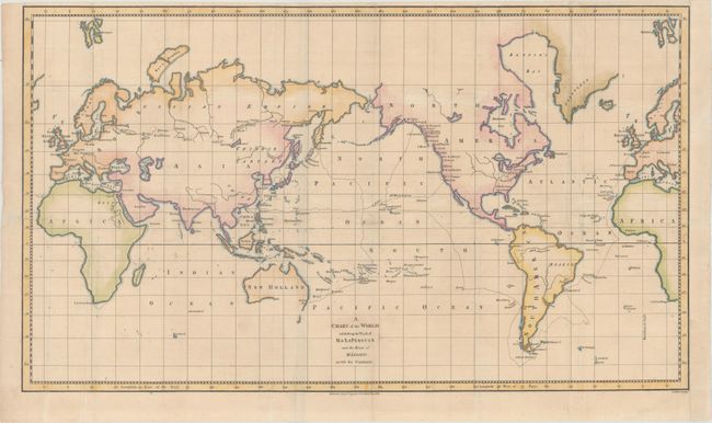
Jean-Francois de Galoup, Comte de La Perouse commanded a French scientific expedition to the Pacific in 1785-88. Recognized as one the foremost naval commanders and navigators in France, he was selected by King Louis XVI to complete Captain James Cook's exploration of the western Pacific. The British Admiralty provided scientific equipment to measure variations in magnetic compass readings and with the latest instruments for determining longitude. La Perouse explored the coasts of the Gulf of Alaska and northwestern North America in search of the fabled Northwest Passage. After leaving America his expedition continued on to Asia where he explored from Macao to Kamchatka and the Solomon Islands in the South Pacific. La Perouse was meticulous in sending copies of his extensive logs, maps and surveying information via other ships as well as overland. La Perouse's last contact was in the spring of 1788 with a British ship in Botany Bay, Australia. The expedition was never heard from again. Considered one of the greatest French voyages, the French Government decided to publish the story of the expedition when it became clear they had been lost. An English edition was published in London.
This map of the world on Mercator's projection is centered on the Pacific Ocean and depicts the track of Jean Francois de Galaup, Comte de La Perouse in his scientific navigation around the world. Barthelemy de Lesseps accompanied the voyage as an interpreter, and disembarked from the ship in September 1787 on the Kamchatka Peninsula in order to bring reports of the voyage safely back to Paris. Lesseps' overland route through Russia and Europe is also shown. Nearly all place names shown are related to the voyages, with very little interior detail in the continents. In order to show both routes in full, parts of Europe and Africa are shown twice at right and left. Engraved by J. Allen.
References: Perry & Prescott #1798.13.
Condition: B+
Issued folding, now flattened, with archival repairs to some minor separations along the folds. There is light soiling and the right margin has been extended to accommodate framing. The top margin is narrow but adequate for framing. There is a bluish shadow running vertically through Australia and Russia, which is caused by our scanner and does not appear on the map itself.