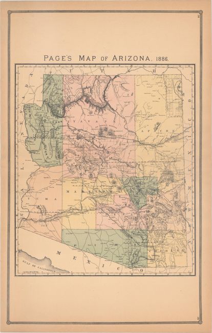
Subject: Arizona
Period: 1886 (dated)
Publication:
Color: Hand Color
Size:
16.4 x 26.4 inches
41.7 x 67.1 cm
This large format map is a scarce issue of the territory by the little known H.R. Page & Co. firm of Chicago. Features only ten counties with Tucson shown as the territorial capital, an obvious error. The capital was first established in Prescott (Fort Whipple) in 1864, moved to Tucson in 1867, then back to Prescott in 1877, and finally to Phoenix in 1889. This map should properly show Prescott as the capital. It locates a large array of roads and trails, principally in the southern half of the territory. In the north is the Atlantic and Pacific Railroad, and the Southern Pacific Railroad is shown in the south. Mining was dominate at this time and all of the mining towns and camps are shown. Filled with interesting place names including Camp Verde and Camp Lincoln, shown about 30 miles apart on the Winslow to Prescott wagon road. This is another obvious error as Camp Lincoln and Camp Verde are one and the same. Camp Lincoln was renamed Camp Verde in 1868 and is today a museum in the town of the same name. A rarely seen map that is a worthy addition to any serious Arizona collection.
References:
Condition: B+
Light toning that is slightly more pronounced along sheet edges. There is a tiny tear adjacent to the centerfold that has been repaired with archival tape on verso.