Subject: Eastern United States
Period: 1825 (dated)
Publication:
Color: Hand Color
Size:
61.6 x 51.8 inches
156.5 x 131.6 cm
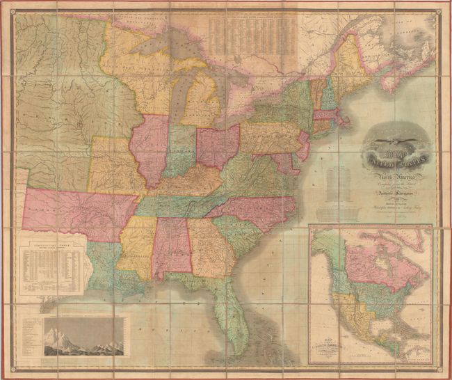
This scarce, first edition map depicts the eastern United States to approximately the 101st meridian, or just west of the present-day Texas panhandle/Oklahoma border. It was drawn by David H. Vance, engraved by J.H. Young, and published by Anthony Finley in Philadelphia. The map shows a large Arkansas Territory that incorporates present-day Oklahoma, and North West Territory consists of Eastern Minnesota and Wisconsin that is "Attached to Michigan." The territory west of the Mississippi River is derived from Stephen Long's map of 1822, and delineates both the "Route of the Expedition commanded by Major Long to the Rocky Mountains" and the "Route of the Expedition commanded by Major Long to Lake Winnipeg." Also noted is the "Route of Traders from Missouri to New Mexico" (Santa Fe Trail). Numerous Indian tribes and villages are located in the West including the lands of the Choctaw, Cherokee, Osage, Pawnee, Sioux, and Mandan Indians to name a few. Indian Boundary Lines are shown in Michigan Territory, Arkansas Territory, and Missouri while Military Bounty Lands from the War of 1812 are identified in both Illinois and Missouri, demonstrating the competing interests along the frontier.
The large map is augmented by several insets including Map of North America Including All the Recent Geographical Discoveries, which later appeared in Finley's 1826 American Atlas and presents the United States' view of the Oregon Boundary Dispute. Additional insets include: "The Principal Steam Boat Routes throughout the United States" including the recently completed Erie Canal; "Statistical Table of the United States;" and "Comparative Elevation of the Principal Mountains and Hills in the United States." The title cartouche uses fancy lettering and is decorated by the emblem of the United States.
Dissected into 40 panels and mounted on original linen with maroon ribbon edging. Self-folding with marbled, stiff paper covers. Later editions are known to have been published in 1828 and 1829.
References: Rumsey #3961; Phillips (Maps) p. 883; Streeter Sale #3820; Inset Map - Wheat #368 (TMW).
Condition: B
Overall good condition with light to moderate toning and foxing. Dissected panels have no chips or tears in the image and are firmly attached to the original linen, which has separated only along one panel at top. Ribbon edging is fully present and intact.